Lava load
| Lava load | ||
|---|---|---|
|
|
||
| region | Nouvelle-Aquitaine | |
| Department | Dordogne | |
| Arrondissement | Bergerac | |
| Canton | Lalinde | |
| Community association | Communes des Bastides Dordogne-Périgord | |
| Coordinates | 44 ° 42 ′ N , 0 ° 52 ′ E | |
| height | 147-220 m | |
| surface | 3.95 km 2 | |
| Residents | 81 (January 1, 2017) | |
| Population density | 21 inhabitants / km 2 | |
| Post Code | 24540 | |
| INSEE code | 24231 | |
| Website | www.lavalade.fr | |
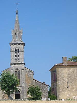
 Center of Lavalade with parish church |
||
Lavalade is a French municipality with 81 inhabitants (at January 1, 2017) in the department of Dordogne in the region Nouvelle-Aquitaine (before 2016: Aquitaine ). The municipality belongs to the arrondissement Bergerac and the canton Lalinde (until 2015: canton Monpazier ).
The name is La Valada in the Occitan language , which is derived from the Latin vallis ( German valley ).
The inhabitants are called Lavaladois and Lavaladoises .
geography
Lavalade is located about 35 km south-east of Bergerac in the Bergeracois region of the historic Périgord province on the southern edge of the department.
Lavalade is surrounded by the neighboring communities:
| Lolme | ||
| Rampieux |

|
Marsals |
| Saint-Cassien |
Lavalade is located in the catchment area of the Dordogne river . The Ruisseau du Fraisse, a tributary of the Véronne, has its source in the commune.
history
A cromlech from the Neolithic period , which is located in the hamlet of Peyrégude, and a coin from the time of the Roman emperor Mark Aurel (121-180), which was found in Lavalade, prove an early settlement of the area. Not far from the center of the municipality, some materials from the Gallo-Roman period have been found, stones from small and medium-sized masonry bonds, tile elements, ceramic fragments and roof tiles. According to the agreements of 1285 and 1286 between Aymeric de Montferrand-Biron and Messire Bertrand de Panissal, Seigneur of Monpazier , the village was annexed to the Bastide of Monpazier. In the center of the municipality you can see the remains of a castle from the 15th century, which was built by Seigneur de Gontaud-Biron.
Toponymy
Toponyms and mentions of Lavalade were:
- Lavalada (1289, Gironde Archives),
- La Valade (1750, map by Cassini ),
- Lavalade (1793, Notice Communale ),
- La Valade (1801 and 1873, Bulletin des Lois and Dictionnaire topographique du département de la Dordogne).
Population development
After records began, the population rose to a peak of around 320 at the beginning of the 19th century. In the following period, the size of the community fell to 55 inhabitants with brief recovery phases until the 1980s, before a moderate growth phase began, which has recently been observed stagnated again.
| year | 1962 | 1968 | 1975 | 1982 | 1990 | 1999 | 2006 | 2010 | 2017 |
|---|---|---|---|---|---|---|---|---|---|
| Residents | 77 | 81 | 77 | 55 | 63 | 80 | 101 | 106 | 81 |
Attractions
Parish Church of Notre-Dame-de-l'Assomption
The church, consecrated to Martin of Tours , was built in the 12th century. Numerous modifications were made over the centuries, in particular with the addition of a bell tower over the vestibule with a pointed arched entrance portal in 1855. The current semicircular apse is not part of the original Romanesque structure and was added later, as were the walls of the first Yoke , which was probably built on old foundations. The floor plan of today's church has the shape of a Latin cross , with the transverse arms of the transept formed by two side chapels . The belt arches of the second, shorter yoke, on the other hand, rest on columns with sculpted capitals and prove that these elements belong to the first building. The capitals of the first arch are decorated with leaf ornamentation, while those of the second arch are embellished with representations. Original sin is illustrated on the north side. In the middle of the basket capital the serpent twines around the tree of knowledge , while Eve picks the fruit on the left and Adam tries to hide his nakedness on the right, a symbol of the awareness of the following violation of the divine rules. On the other side of the pillar is a tree of life, which symbolizes continued existence despite sin and the anticipation of future salvation. A bird on the right is likely to echo the spirit in a person. Palmettes decorate the beginning of a cornice and suggest that they once adorned the walls of the former nave . The capital of the right pillar is covered by two lions, whose bodies unite at the top to form a head with a monster grimace.
Cromlech
It is a very thick limestone block with a height of 2.5 m and a circumference of 5 m at the bottom. Smaller blocks of stone surround the erected stone. A few meters away there are two or three types of rows of stones .
Economy and Infrastructure
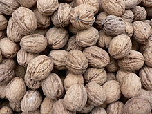
Lavalade is located in the AOC zones of the Noix du Périgord , the walnuts of the Périgord, and the nut oil of the Périgord.

total = 13
sport and freetime
The GR 36, a long-distance hiking trail from Ouistreham in Normandy to Bourg-Madame in the eastern Pyrenees , also runs through the territory of the municipality.
traffic
The Route départementale 660, the former Route nationale 660 , crosses the area of the municipality from northwest to southeast and connects Lavalade with Bergerac in the northwest, Monpazier in the southeast and further on with Cahors .
Web links
- Lavalade on the Pays de Bergerac Tourisme website (French)
- Information on Périgord walnuts and Périgord nut oil (French)
Individual evidence
- ↑ Le nom occitan des communes du Périgord ( fr ) Départementrat des Dordogne. Retrieved November 17, 2018.
- ↑ a b c Lavalade ( fr ) Conseil régional d'Aquitaine. Archived from the original on September 11, 2016. Retrieved November 17, 2018.
- ↑ Ma commune: Lavalade ( fr ) Système d'Information sur l'Eau du Bassin Adour Garonne. Retrieved November 17, 2018.
- ↑ a b c Elisée Cérou: La commune de Lavalade ( fr , PDF) Groupe Archéologique Mons-Paciarus. 1990. Retrieved October 17, 2018.
- ↑ Dominique Ursy: Les monnaies romaines découvrtes sur Monpazier ( fr , PDF) Groupe Archéologique Mons-Paciarus. 2010. Retrieved October 17, 2018.
- ^ Paul Vicomte de Gourgues: Dictionnaire topographique du département de la Dordogne ( fr ) In: Dictionnaire topographique de la France . Imprimerie nationale. P. 331, 1873. Retrieved November 17, 2018.
- ^ France 1750 ( en ) David Rumsey Map Collection: Cartography Associates. Retrieved November 17, 2018.
- ↑ a b Notice Communale Lavalade ( fr ) EHESS . Retrieved November 17, 2018.
- ↑ Populations légales 2015 Commune de Lavalade (24231) ( fr ) INSEE . Retrieved November 17, 2018.
- ^ Eglise Saint-Martin ( fr ) Observatoire du patrimoine religieux. Retrieved November 17, 2018.
- ^ Jean-Pierre Verdon: L'église de Lavalade ( fr , PDF) Groupe Archéologique Mons-Paciarus. 2004. Retrieved October 17, 2018.
- ↑ Mairie de Lavalade ( fr ) Pays de Bergerac Tourisme. Retrieved November 17, 2018.
- ↑ Institut national de l'origine et de la qualité: Rechercher un produit ( fr ) Institut national de l'origine et de la qualité . Retrieved November 30, 2018.
- ↑ Caractéristiques des établissements en 2015 Commune de Lavalade (24231) ( fr ) INSEE . Retrieved November 17, 2018.
- ↑ GR36 - Randonnée de Les Eyzies-de-Tayac-Sireuil (Dordogne) à Prayssac (Lot) ( fr ) gr-infos.com. Retrieved November 17, 2018.


