
Saint-Aubin-de-Lanquais
| Saint-Aubin-de-Lanquais | ||
|---|---|---|
|
||
| region | Nouvelle-Aquitaine | |
| Department | Dordogne | |
| Arrondissement | Bergerac | |
| Canton | Sud-Bergeracois | |
| Community association | Communes de Portes Sud Périgord | |
| Coordinates | 44 ° 48 ' N , 0 ° 36' E | |
| height | 64-147 m | |
| surface | 9.27 km 2 | |
| Residents | 343 (January 1, 2017) | |
| Population density | 37 inhabitants / km 2 | |
| Post Code | 24560 | |
| INSEE code | 24374 | |
 View of the center of Saint-Aubin-de-Lanquais |
||

Saint-Aubin-de-Lanquais is a French municipality with 343 inhabitants (at January 1, 2017) in the department of Dordogne in the region Nouvelle-Aquitaine (before 2016: Aquitaine ). The municipality belongs to the Arrondissement Bergerac and the canton Sud-Bergeracois (until 2015: canton Issigeac ).
The name in the Occitan language is Sench Albin de Lancais and is derived from the holy Albin of Angers . The addition "Lanquais" is explained by the fact that it belonged to the Vicomté of Lanquais for several centuries.
The inhabitants are called Saint-Aubinois and Saint-Aubinoises or Saint-Aubinois-de-Lanquais and Saint-Aubinoises-de-Lanquais .
geography
Saint-Aubin-de-Lanquais is located approx. 11 km southeast in the catchment area ( Aire urbaine ) of Bergerac in the Bergeracois area of the historic province of Périgord on the southern edge of the department.
The commune is irrigated by the Couillou and the Conne , two tributaries of the Dordogne .
Saint-Aubin-de-Lanquais is surrounded by the neighboring municipalities:
| Saint-Germain-et-Mons | Verdon | |
| Saint-Nexans |
.svg)
|
Faux |
| Conne-de-Labarde | Saint-Cernin-de-Labarde | Monmadalès |
Population development
After records began, the number of inhabitants rose to a high of around 610 in the middle of the 19th century. In the period that followed, a phase of stagnation set in, which caused the number of inhabitants to fall to 220 inhabitants by the 1980s with short recovery phases. before a growth phase began that continues to this day.
| year | 1962 | 1968 | 1975 | 1982 | 1990 | 1999 | 2006 | 2011 | 2017 |
|---|---|---|---|---|---|---|---|---|---|
| Residents | 294 | 270 | 247 | 220 | 232 | 256 | 264 | 304 | 343 |

Attractions
- Saint-Aubin parish church from the 16th century
- Saint-Aubin castle from the 19th century

Parish Church of Saint-Aubin
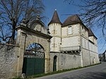
Saint-Aubin Castle


Economy and Infrastructure

Agriculture is based on the cultivation of grain, livestock and viticulture.
Saint-Aubin-de-Lanquais is located in the AOC des Bergerac with the appellations Bergerac (blanc, rosé, rouge) and Côtes de Bergerac (blanc, rouge) as well as the Périgord nut oil.

Total = 23
traffic
Saint-Aubin-de-Lanquais can be reached via Routes départementales 19 and 21.
Web links
- Saint-Aubin-de-Lanquais on the Association of Municipalities website (French)
- Information about Bergerac wines
- Information on Périgord nut oil (French)
Individual evidence
- ↑ Le nom occitan des communes du Périgord ( fr ) Départementrat des Dordogne. Retrieved January 9, 2019.
- ↑ a b c Saint-Aubin-de-Lanquais ( fr ) Conseil régional d'Aquitaine. Archived from the original on September 9, 2016. Retrieved January 9, 2019.
- ↑ Dordogne ( fr ) habitants.fr. Retrieved January 9, 2019.
- ↑ Aire urbaine de Bergerac (109) ( fr ) INSEE . Retrieved January 9, 2019.
- ↑ Notice Communale Saint-Aubin-de-Lanquais ( fr ) EHESS . Retrieved January 9, 2019.
- ↑ Populations légales 2016 Commune de Saint-Aubin-de-Lanquais (24374) ( fr ) INSEE . Retrieved January 9, 2019.
- ↑ Institut national de l'origine et de la qualité: Rechercher un produit ( fr ) Institut national de l'origine et de la qualité . Retrieved January 9, 2019.
- ↑ Caractéristiques des établissements en 2015 Commune de Saint-Aubin-de-Lanquais (24374) ( fr ) INSEE . Retrieved January 9, 2019.