Bardou (Dordogne)
|
Bardou Bardon |
||
|---|---|---|
|
|
||
| region | Nouvelle-Aquitaine | |
| Department | Dordogne | |
| Arrondissement | Bergerac | |
| Canton | Sud-Bergeracois | |
| Community association | Portes Sud Périgord | |
| Coordinates | 44 ° 44 ′ N , 0 ° 41 ′ E | |
| height | 124-181 m | |
| surface | 4.76 km 2 | |
| Residents | 45 (January 1, 2017) | |
| Population density | 9 inhabitants / km 2 | |
| Post Code | 24560 | |
| INSEE code | 24024 | |
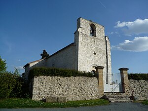
 Saint Blaise Church |
||
Bardou ( Occitan : Bardon ) is a French municipality with 45 inhabitants (at January 1, 2017) in the department of Dordogne , in the region Nouvelle-Aquitaine ; it belongs to the Arrondissement of Bergerac and the canton of Sud-Bergeracois .
geography
The municipality is located around 18 kilometers south-east of Bergerac in the Périgord Noir countryside . Neighboring municipalities of Bardou are Monsac in the north, Nausannes in the east, Saint-Léon-d'Issignac in the southeast, Boisse in the southwest and Montaut in the west.
A small ridge runs through the municipality, which means that the river Banège rises in the eastern area , which drains to the southwest to the Dropt and on to the Garonne , while in the northwestern municipality there are the sources of the Couzeau river , which runs north to the Dordogne runs.
Transport links
Bardou is away from national traffic connections. The commune is accessed from the D25 départemental road that leads from Eymet to Beaumont-du-Périgord .
Population development
| year | 1968 | 1975 | 1982 | 1990 | 1999 | 2009 | 2016 |
| Residents | 54 | 58 | 43 | 36 | 33 | 41 | 44 |
