
Gardonne
|
Gardonne Gardona |
||
|---|---|---|

|
|
|
| region | Nouvelle-Aquitaine | |
| Department | Dordogne | |
| Arrondissement | Bergerac | |
| Canton | Pays de la Force | |
| Community association | Bergeracoise | |
| Coordinates | 44 ° 50 ′ N , 0 ° 20 ′ E | |
| height | 10-35 m | |
| surface | 8.26 km 2 | |
| Residents | 1,592 (January 1, 2017) | |
| Population density | 193 inhabitants / km 2 | |
| Post Code | 24680 | |
| INSEE code | 24194 | |
| Website | http://www.gardonne.fr/ | |

Gardonne ( Occitan : Gardona ) is a French commune in the department of Dordogne in the region Nouvelle-Aquitaine . The municipality with 1,592 inhabitants (as of January 1, 2017) is located in the canton of Pays de la Force (until 2015: canton Sigoulès ) and in the Arrondissement of Bergerac . The inhabitants of the municipality are called gardonnais .
geography
Gardonne is about eleven kilometers west-southwest of Bergerac on the Dordogne , which borders the municipality in the north. Gardonne is surrounded by the neighboring communities of Saint-Pierre-d'Eyraud in the north, Lamonzie-Saint-Martin in the east, Gageac-et-Rouillac in the southeast, Saussignac in the south, Razac-de-Saussignac in the southwest and Saint-Avit-Saint- Nazaire to the west.
The former route nationale 136 (today's D936) runs through the municipality .
Population development
| 1962 | 1968 | 1975 | 1982 | 1990 | 1999 | 2006 | 2017 | |
|---|---|---|---|---|---|---|---|---|
| 773 | 988 | 1115 | 1130 | 1383 | 1404 | 1356 | 1592 | |
| Sources: Cassini and INSEE | ||||||||
Attractions
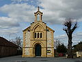
- 19th century catholic church Saint-Jean-Baptiste
- protestant church
- Pigeon houses

Saint-Jean-Baptiste church
protestant church

Half-timbered house


Parish partnership
There is a partnership with the French community of Guémar in the Haut-Rhin (Alsace) department.