
Bouniagues
| Bouniagues | ||
|---|---|---|

|
|
|
| region | Nouvelle-Aquitaine | |
| Department | Dordogne | |
| Arrondissement | Bergerac | |
| Canton | Sud-Bergeracois | |
| Community association | Communauté d'agglomération Bergeracoise | |
| Coordinates | 44 ° 46 ' N , 0 ° 32' E | |
| height | 74-181 m | |
| surface | 8.62 km 2 | |
| Residents | 587 (January 1, 2017) | |
| Population density | 68 inhabitants / km 2 | |
| Post Code | 24560 | |
| INSEE code | 24054 | |
| Website | www.bouniagues.com | |
 View of the center of Bouniagues |
||

Bouniagues is a French municipality with 587 inhabitants (at January 1, 2017) in the department of Dordogne in the region Nouvelle-Aquitaine (before 2016: Aquitaine ). The municipality belongs to the Arrondissement Bergerac and the canton Sud-Bergeracois (until 2015: canton Issigeac ).
The name in the Occitan language is Bonhagas . One theory says that it goes back to an estate in Gallo-Roman times that belonged to a certain "Bonius". Another theory assumes that it is derived from the Latin bonnae aquae ( German good water ).
The inhabitants are called Bouniaguais and Bouniaguaises .
geography
Bouniagues is about 10 km south and thus in the catchment area ( Aire urbaine ) of Bergerac in the Bergeracois region of the historic province of Périgord .
Bouniagues is surrounded by the neighboring communities:
| Colombier | Conne-de-Labarde | |
| Ribagnac |
.svg)
|
Saint-Cernin-de-Labarde |
| Sadillac | Saint-Perdoux | Monsaguel |
Bouniagues is located in the catchment area of the Dordogne river . The Gardonnette, one of its tributaries, has its source in the municipality.

history
In the 12th century Bouniagues was the seat of an archpriesthood with 59 parishes , which was under the diocese of Sarlat . Many families, including the Solminihacs and de Saint-Ours, followed at the top of manorial each other. As a result, the village gradually developed, in particular through the manufacture of roof tiles. As early as 1610, a small production of roof and wall tiles was mentioned. The convenient location on the Route Royale , which led from Paris to Madrid , favored sales.
Toponymy
Toponyms and mentions of Bouniagues were:
- Bognagas (1315, Collection de l'abbé de Lespine ),
- Bouhagnas (1365),
- Bonhagnes (1465, Pau archive ),
- Bouhagnis (1502, Collection de l'abbé de Lespine ),
- Bounagnies (1556, shield of the dioceses of Périgueux and Sarlat),
- Bougniagues (1739, notaries from Bergerac),
- Bouniague (1750, map by Cassini ),
- Boumagne (1793, Notice Communale ),
- Bouniagues (1801, Bulletin des Lois ).
Population development
After records began, the population rose to an initial high of around 545 in the second half of the 19th century. In the following period, the size of the community fell to around 320 inhabitants during brief recovery phases until the 1930s, before a robust growth phase began. which continues today and reaches new highs.
| year | 1962 | 1968 | 1975 | 1982 | 1990 | 1999 | 2006 | 2010 | 2017 |
|---|---|---|---|---|---|---|---|---|---|
| Residents | 380 | 349 | 378 | 447 | 466 | 476 | 487 | 517 | 587 |

Attractions
.jpg)
Parish Church of Notre-Dame-de-l'Assomption
The church, consecrated in honor of Mary's Assumption into Heaven , was built in 1882 in neo-Gothic style according to plans by the architect Robertien de Bergerac . The mayor Martial Delpit gave the church a stained glass window depicting Alain de Solminihac (1593–1659), Bishop of Cahors from 1637.

Bouniagues Castle
It is a permanent house that was built in the 15th century. Around 1875 the mayor of the parish Martial Delpit de Castang bought the property and gave half of it back to the parish in order to set up a rectory there. This occupies the western part of the manor house, which has been reduced by one storey. A polygonal stair tower accentuates the central part of the building. At its foot there is an ogival entrance to an anteroom. A coat of arms can be seen above the lintel , held by two mythical animals that are reminiscent of bears, perhaps reminiscent of the de Saint-Ours family (“Ours” (French) corresponds to “bear” (German)), who when Seigneurs von Bouniagues lived here around 1790. Pierre De Saint-Ours was betrayed by one of his servants during the French Revolution in 1793 and shackled and gagged while he was sleeping. After looting the castle, the Bergerac Revolutionary Tribunal henchmen put him, his wife, and eight children on a cart. The train almost reached Bergerac when the farmers of Bouniagues, armed with rifles, spears and scythes, freed the family, who were able to return to their castle and henceforth unmolested. The rectory is now owned by a private person. The Renaissance style entrance has been inscribed as a Monument historique since January 27, 1948 .
- Bouniagues Castle
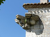
Capitals on the corners of the castle building

Entrance to the rectory
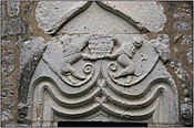
Detail of the lintel
.jpg)

_-_D%C3%A9tail_linteau_du_Presbyt%C3%A8re.JPG)

Nature reserve
On the border to the southern neighboring village of Saint-Avit-Rivière on a wasteland , a 14.35-hectare natural area zone naturelle d'intérêt écologique, faunistique et floristic type 1. The interest here is the flora , especially the rare upright Heideröschen ( Fumana ericoides ).
Economy and Infrastructure

Trade and services are the main economic drivers of the community today.
Bouniagues is located in the AOC des Bergerac zone with the Bergerac and Côtes de Bergerac appellations .

total = 81
education
The municipality has a public preschool and elementary school with 21 pupils in the 2018/2019 school year.
sport and freetime
- The Boucle des grandes vignes - Bouniagues circular route is 6.4 km long with a difference in altitude of 44 m. It leads from the center through the area of the municipality past the castle and the vineyards.
- The A vélo autour de Monbazillac circular route for cyclists is 24 km long with a difference in altitude of 41 m. It starts in Monbazillac and also runs through the center of Bouniagues.
traffic
Bouniagues can be reached via Routes départementales 13 and 14 and via Route nationale 21 , which crosses the municipality and connects with Bergerac.
Web links
- Bouniagues on the Pays de Bergerac Tourisme website (French)
- Bouniagues on the association's website (French)
- Information about Bergerac wines
Individual evidence
- ↑ Le nom occitan des communes du Périgord ( fr ) Départementrat des Dordogne. Retrieved October 5, 2018.
- ↑ a b Bouniagues ( fr ) Conseil régional d'Aquitaine. Archived from the original on September 9, 2016. Retrieved October 5, 2018.
- ↑ Dordogne ( fr ) habitants.fr. Retrieved October 5, 2018.
- ↑ Ma commune: Bouniagues ( fr ) Système d'Information sur l'Eau du Bassin Adour Garonne. Retrieved October 5, 2018.
- ↑ a b Paul Vicomte de Gourgues: Dictionnaire topographique du département de la Dordogne ( fr ) In: Dictionnaire topographique de la France . Imprimerie nationale. P. 35, 1873. Retrieved October 5, 2018.
- ^ France 1750 ( en ) David Rumsey Map Collection: Cartography Associates. Retrieved October 5, 2018.
- ↑ a b Notice Communale Bouniagues ( fr ) EHESS . Retrieved October 5, 2018.
- ↑ Populations légales 2006 Commune de Bouniagues (24054) ( fr ) INSEE . Retrieved October 5, 2018.
- ↑ Populations légales 2015 Commune de Bouniagues (24054) ( fr ) INSEE . Retrieved October 5, 2018.
- ↑ a b Histoire & Patrimoine ( fr ) Municipality of Bouniagues. Retrieved October 5, 2018.
- ^ Presbytère ( fr ) Ministry of Culture and Communication . September 22, 2015. Accessed October 5, 2018.
- ↑ ZNIEFF 720014244 - FRICHE CALCAIRE DE LA BECQUERIE ( fr ) Inventaire national du patrimoine naturel (INPN). Retrieved December 13, 2018.
- ↑ Institut national de l'origine et de la qualité: Rechercher un produit ( fr ) Institut national de l'origine et de la qualité . Retrieved October 5, 2018.
- ↑ Caractéristiques des établissements en 2015 Commune de Bouniagues (24054) ( fr ) INSEE . Retrieved October 5, 2018.
- ^ École maternelle et élémentaire ( fr ) National Ministry of Education. Retrieved October 5, 2018.
- ↑ Boucle des grandes vignes - Bouniagues ( fr ) Institut national de l'information géographique et forestière (IGN). April 18, 2018. Retrieved October 5, 2018.
- ↑ A vélo autour de Monbazillac ( fr ) Institut national de l'information géographique et forestière (IGN). April 18, 2018. Retrieved October 5, 2018.