Montferrand-du-Périgord
| Montferrand-du-Périgord | ||
|---|---|---|

|
|
|
| region | Nouvelle-Aquitaine | |
| Department | Dordogne | |
| Arrondissement | Bergerac | |
| Canton | Lalinde | |
| Community association | Communes des Bastides Dordogne-Périgord | |
| Coordinates | 44 ° 45 ′ N , 0 ° 52 ′ E | |
| height | 85-234 m | |
| surface | 13.10 km 2 | |
| Residents | 157 (January 1, 2017) | |
| Population density | 12 inhabitants / km 2 | |
| Post Code | 24440 | |
| INSEE code | 24290 | |
| Website | montferrand-du-perigord.fr | |
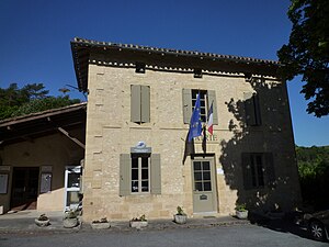
 Mairie (Town Hall) |
||
Montferrand-du-Périgord is a French municipality with 157 inhabitants (at January 1, 2017) in the department of Dordogne in the region Nouvelle-Aquitaine (before 2016: Aquitaine ). The municipality belongs to the Arrondissement of Bergerac and the canton of Lalinde (until 2015: canton of Beaumont-du-Périgord ).
The name is Mont Ferrand de Perigòrd in the Occitan language . There are various explanations about its origin. It could mean "Mountain of Ferrandus", a person of Germanic origin. The name could come from the name of the Ferrenc family ( German man, hard as iron ), or it could be derived from the Germanic root ferh ( German life ).
The inhabitants are called Montferrandais and Montferrandaises .
geography
Montferrand-du-Périgord is located approx. 35 km southeast of Bergerac in the Bergeracois area of the historic province of Périgord .
Montferrand-du-Périgord is surrounded by the neighboring municipalities:
| Saint-Avit-Sénieur | Le Buisson-de-Cadouin | |

|
Bouillac | |
| Sainte-Croix | Saint-Romain-de-Monpazier | Saint-Avit-Rivière |
Montferrand-du-Périgord lies in the catchment area of the Dordogne river .
The Couze , one of its tributaries, crosses the territory of the municipality. Likewise, Montferrand-du-Périgord is irrigated by its tributaries,
- the Ségurel and its tributary,
- the Salvetat, and
- the Ruisseau de Tournier.
history
At various sites in the municipality, tools from prehistoric times have come to light, which prove that the area was settled from this era. Three sarcophagi from the Merovingian era have been discovered in a hamlet and a quarry. The Montferrand Seigneurs family is divided into two branches. The older one emerged in 1163 from the marriage of Berthe, lady from Montferrand and daughter of the builder of the castle, with Vital de Gontaut. The house of Gontaut had held a considerable social position in the Duchy of Gascon since the year 1100 . From the other branch of the family, the Gontaut-Birons, came the Seigneurs from Montferrand up to the French Revolution . In the 13th century Montferrand was under the jurisdiction of Beaumont , in the 14th century the castellany of Beaumont. The last seigneur, Charles-Antoine, disappeared in 1798 and his estates were divided up. Antoine de Grammont, the twelfth in succession, received the castle and its outbuildings in 1805. At the beginning of the revolution, the municipality became the capital of a newly founded canton in 1790, which included the municipalities of Bouillac, Rampieux , Lolme , Sainte-Croix and Saint-Marcory . But the canton was dissolved as early as 1801 and Montferrand was added to the canton of Beaumont-du-Périgord. In 1894 the municipality changed its name to Montferrand-du-Périgord.
Toponymy
Toponyms and mentions of Montferrand-du-Périgord were:
- Castrum de Monte Ferrando (1272, custom of the Beaumont castellany),
- Monferrand (1750, map by Cassini ),
- Montferrand (1793, Notice Communale ),
- Monferrand (1801, Bulletin des Lois ),
- Montferrand (1873, Dictionnaire topographique du département de la Dordogne),
- Montferrand-du-Périgord (1894).
Population development
After the beginning of the records, the population rose to a high of around 785 at the beginning of the 19th century. In the following period, the size of the community could be kept approximately at a level of over 700 inhabitants until the middle of the same century. This was followed by a phase of stagnation that continues today.
| year | 1962 | 1968 | 1975 | 1982 | 1990 | 1999 | 2006 | 2010 | 2017 |
|---|---|---|---|---|---|---|---|---|---|
| Residents | 232 | 236 | 211 | 185 | 197 | 180 | 172 | 177 | 157 |
Attractions
The municipality has 25 buildings that are listed as national cultural assets. Four of these are inscribed as Monument historique .
Saint-Christophe Church
The Romanesque church consecrated to St. Christopher was built at the end of the 11th century. It is located approx. 800 m southwest of the center of the municipality. The church has been inscribed as a Monument historique since July 12, 2001 .
Parish Church of Saint-Christophe
It was built in the center of the community in 1849 and replaced the medieval church as a parish church. Perhaps as a result of a dispute among residents of the central square, the church is oriented to the west , which is not unusual for sacred buildings of that era. Numerous pieces of equipment from the 19th and 20th centuries are registered as national cultural assets. These include twelve glass windows , works by the glass painter Antoine Bernard from Grenoble , from the years 1919 to 1925.
Castle
The keep and castle wall date from the 12th century, when the aristocratic seat belonged to the bastide of Beaumont. The chapel and community building were built in the 16th and 17th centuries. The castle consisted of two curtain walls, which were separated by a moat . Curtains connected round towers. In the course of the 19th century, Pastor Treille bought the castle and had the fortifications removed. In 1922 it passed into the hands of the descendants of David de Faubournet's family from Montferrand. The square keep is now one of the oldest preserved towers in Périgord. Its west side is decorated in the middle with a buttress , from which its dating can be determined. A second, more spacious tower, located in the extension of the keep and a few steps away, served as a residential wing. This area was accessible at a great height using a retractable bridge. The castle has been inscribed as a Monument historique since November 29, 2013 . It is privately owned and not open to the public.
Regagnac Castle
It is located in the hamlet of the same name in the northeastern part of the municipality. The oldest document mentioning the castle dates back to 1597 and shows that it was in the possession of Anne du Peyret, widow of Charles de Foucault, the Seigneur of Regagnac. Around 1645 it passed into the hands of Izac de Rouby. When Anne Rouby married Jean Vaquier, she brought the castle into the possession of the Vaquier family, merchants from the hamlet of Boulègue. According to local tradition, materials from an earlier structure a few hundred meters to the north were used in the construction of the castle. The buildings south of the inner courtyard were redesigned or rebuilt in the 19th and 20th centuries. The L-shaped wing of the residential building north of the inner courtyard dates from the 16th and 17th centuries. After the French Revolution, the castle belonged to the Wacquier family, and in the second half of the 19th century to the Davoust and de Boysson families. Today guest rooms are offered in the castle.
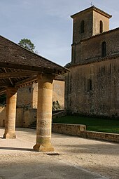
Market hall
Today's market hall was rebuilt between 1911 and 1914 on the square in front of the church. Sixteen round pillars made of ashlar support the ceiling construction, which is covered by flat bricks. The capitals probably date from the 18th century. The first pillar on the left in the direction of the church has a flattened point. It was once used as a pillory , with the judgment posted on the flat part. The building measures 12 x 12 m and is one of the largest market halls in the Périgord. It has been inscribed as a Monument historique since January 5, 1948 .
Economy and Infrastructure
The municipality's economy is based on tourism, agriculture and forestry, as well as craft and trade.
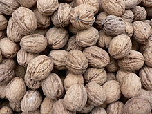
Montferrand-du-Périgord is located in the AOC zones of the Noix du Périgord , the walnuts of the Périgord, and the nut oil of the Périgord.

total = 24
education
The municipality has a public preschool and elementary school with 20 students in the 2018/2019 school year.
sport and freetime
The GR 36, a long-distance hiking trail from Ouistreham in Normandy to Bourg-Madame in the eastern Pyrenees , also runs through the center of the municipality.
traffic
The Route départementale 2 passes through the territory of the municipality from north to south and connects Montferrand with the neighboring village of Le Buisson-de-Cadouin on the road axis Bergerac Sarlat-la-Caneda in the north and with Monpazier in the south.
Route départementale 26 crosses the territory of the municipality from west to east and connects Montferrand with Route départementale 660, the former Route nationale 660 , in the west and east with the neighboring municipality of Bouillac.
Personalities
Charles Lenormand, born in Paris on October 2, 1833 , died in 1904, was an architect and photographer. He found his final resting place in the Montferrand cemetery. He designed, among other things, the Basilica of the Assumption in Nice and the Notre-Dame-Immaculée Cathedral in Monaco-Ville . In Montferrand-du-Périgord he built his domicile on the property of a former farm on the plateau on the opposite side of the Couze from the center. In 1921 Simone de Saint-Exupéry , war widow and sister of Antoine de Saint-Exupéry , moved into the house with her two daughters. They called it Castelnoël ("new castle"), a name that stayed in the family who still own it today.
Web links
- Montferrand-du-Périgord on the Pays de Bergerac Tourisme website (French)
- Information on Périgord walnuts and Périgord nut oil (French)
Individual evidence
- ↑ Le nom occitan des communes du Périgord ( fr ) Départementrat des Dordogne. Retrieved December 13, 2018.
- ↑ a b Montferrand-du-Périgord ( fr ) Conseil régional d'Aquitaine. Archived from the original on March 13, 2016. Retrieved December 13, 2018.
- ↑ Dordogne ( fr ) habitants.fr. Retrieved December 13, 2018.
- ↑ Ma commune: Montferrand-du-Périgord ( fr ) Système d'Information sur l'Eau du Bassin Adour Garonne. Retrieved December 13, 2018.
- ↑ a b Paul Vicomte de Gourgues: Dictionnaire topographique du département de la Dordogne ( fr ) In: Dictionnaire topographique de la France . Imprimerie nationale. 206. 1873. Retrieved December 13, 2018.
- ↑ a b c Notice Communale Montferrand-du-Périgord ( fr ) EHESS . Retrieved December 13, 2018.
- ^ France 1750 ( en ) David Rumsey Map Collection: Cartography Associates. Retrieved December 13, 2018.
- ↑ Populations légales 2006 Commune de Montferrand-du-Périgord (24290) ( fr ) INSEE . Retrieved December 13, 2018.
- ↑ Populations légales 2015 Commune de Montferrand-du-Périgord (24290) ( fr ) INSEE . Retrieved December 13, 2018.
- ↑ List of buildings in the register of national cultural assets ( fr ) Ministry of Culture and Communication . Retrieved December 13, 2018.
- ↑ église paroissiale dite chapelle Saint-Christophe. ( fr ) Ministry of Culture and Communication . September 24, 2011. Accessed December 13, 2018.
- ^ Eglise Saint-Christophe ( fr ) Ministry of Culture and Communication . September 22, 2015. Accessed December 13, 2018.
- ↑ église paroissiale Saint-Christophe. ( fr ) Ministry of Culture and Communication . July 8, 1999. Retrieved December 13, 2018.
- ↑ 12 verrières (baies 0 to 7, 101 to 104). ( fr ) Ministry of Culture and Communication . May 4, 2004. Retrieved December 13, 2018.
- ↑ Connaître Montferrand n ° 3: Les deux églises ( fr , PDF) Municipality of Montferrand-du-Périgord. 2015. Accessed December 13, 2018.
- ^ Château de Montferrand ( fr ) Ministry of Culture and Communication . September 24, 2011. Accessed December 13, 2018.
- ^ Château de Montferrand ( fr ) Ministry of Culture and Communication . September 22, 2015. Accessed December 13, 2018.
- ↑ Château de Montferrand du Périgord ( fr ) chateau-fort-manoir-chateau.eu. Retrieved December 13, 2018.
- ↑ maison de maître dite Château de Regagnac. ( fr ) Ministry of Culture and Communication . July 8, 1999. Retrieved December 13, 2018.
- ↑ Château de Regagnac ( fr ) chateau-fort-manoir-chateau.eu. Retrieved December 13, 2018.
- ↑ hall ( fr ) Ministry of Culture and Communication . September 24, 2011. Accessed December 13, 2018.
- ^ Halle couverte ( fr ) Ministry of Culture and Communication . September 22, 2015. Accessed December 13, 2018.
- ↑ Mairie de Montferrand du Périgord ( fr ) Pays de Bergerac Tourisme. Retrieved December 13, 2018.
- ↑ Institut national de l'origine et de la qualité: Rechercher un produit ( fr ) Institut national de l'origine et de la qualité . Retrieved December 13, 2018.
- ↑ Caractéristiques des établissements en 2015 Commune de Montferrand-du-Périgord (24290) ( fr ) INSEE . Retrieved December 13, 2018.
- ^ École maternelle et élémentaire ( fr ) National Ministry of Education. Retrieved December 13, 2018.
- ↑ GR36 - Randonnée de Les Eyzies-de-Tayac-Sireuil (Dordogne) à Prayssac (Lot) ( fr ) gr-infos.com. Retrieved December 13, 2018.
- ↑ Connaître Montferrand n ° 8: Cavard et Dourite ( fr , PDF) Municipality of Montferrand-du-Périgord. 2015. Accessed December 13, 2018.


