
Ribagnac
| Ribagnac | ||
|---|---|---|
|
||
| region | Nouvelle-Aquitaine | |
| Department | Dordogne | |
| Arrondissement | Bergerac | |
| Canton | Sud-Bergeracois | |
| Community association | Agglomération Bergeracoise | |
| Coordinates | 44 ° 46 ′ N , 0 ° 30 ′ E | |
| height | 78-183 m | |
| surface | 11.81 km 2 | |
| Residents | 308 (January 1, 2017) | |
| Population density | 26 inhabitants / km 2 | |
| Post Code | 24240 | |
| INSEE code | 24351 | |
.JPG) Bridoire Castle in Ribagnac |
||

Ribagnac is a French municipality with 308 inhabitants (at January 1, 2017) in the department of Dordogne in the region Nouvelle-Aquitaine (before 2016: Aquitaine ). The municipality belongs to the Arrondissement Bergerac and the canton Sud-Bergeracois (until 2015: Canton Sigoulès ).
The name in the Occitan language is Ribanhac , which is derived from an estate that belonged to a "Ripanius" in Gallo-Roman times .
The inhabitants are called Ribagnacois and Ribagnacois .

geography
Ribagnac is located about 10 km south in the catchment area ( Aire urbaine ) of Bergerac in the Bergeracois area of the historic province of Périgord on the southern edge of the department.
Ribagnac is surrounded by the neighboring communities:
| Rouffignac-de-Sigoulès | Monbazillac | Colombier |
| Singleyrac |
.svg)
|
Bouniagues |
| Sadillac | Saint-Perdoux |
Ribagnac lies in the catchment area of the Dordogne river .
The Gardonnette, one of its tributaries, irrigates the area of the municipality together with its tributary, the Grimoudou, which rises in Ribagnac.
history
Ribagnac shows numerous traces of settlement in Gallo-Roman times, which is evidenced, among other things, by the remains of a manufacture of small amphorae . Excavations revealed that a Roman road ran through the settlement. It was made of stones that were connected with mortar . Ribagnac had belonged to the archpriesthood of Bouniagues before a priory was established there from the 12th century under the Abbey of Paunat , which in turn was dependent on the Abbey of Saint-Martial of Limoges . The priory disappeared during the Huguenot Wars . In the Middle Ages , Ribagnac was part of the judicial district of Bridoire.
Toponymy
Toponyms and mentions of Ribagnac were:
- Ribanac (12th century, font collection of the Abbé de Lespine),
- Ribagnac (1750, 1793 and 1801, map from Cassini , Notice Communale or Bulletin des Lois ).
Toponyms and mentions of Bridoire were:
- Buridorium ( copy book of the Abbey of La Sauve-Majeure ),
- Brujdora, (1226, donated in favor of Robert von Arbrissel , according to the collection of the Abbé de Lespine),
- Castrum de Bridoira and Bridoyra (1273, homage to Marguerite de Turenne),
- Bridoria, (1343, homage to the Bishop of Sarlat , according to the collection of the Abbé de Lespine),
- Bridouyre, (1743, notarial deed),
- Bridourc (1750, map by Cassini).
Population development
After records began, the number of inhabitants rose to a high of around 515 by the first half of the 19th century. In the period that followed, a phase of stagnation set in, with the number of inhabitants falling to around 195 after a short recovery period by the 1970s before a phase of growth began that continues today.
| year | 1962 | 1968 | 1975 | 1982 | 1990 | 1999 | 2006 | 2010 | 2017 |
|---|---|---|---|---|---|---|---|---|---|
| Residents | 246 | 225 | 193 | 224 | 278 | 291 | 305 | 320 | 308 |

Attractions
Saint-Pierre-ès-Liens parish church
The church, which dates from the 12th century, has retained its Romanesque apse . The west facade, which is crowned by a bell gable, was restored in the 19th century.
Bridoire Castle

At the site of today's castle there was an oppidum in Roman times in the far northwest of today's municipality at the confluence of the Gardonnette and Grimoudou rivers. It protected the river crossing of the Roman road via Rubana , which connected today's Cadouin with today's Gardonne . The castle was built before the 12th century. During the Hundred Years War it served as the seat of looters. During the Huguenot Wars, the castle was first occupied by the Protestant party before it was besieged and taken by the troops of Blaise de Montesquiou in 1570 . The castle was rebuilt under the French King Henry IV before it was again besieged and razed on the orders of Bernard de Nogaret de La Valette d'Épernon . The castle was subsequently restored in 1890. The Foucauld family lived there from 1806 to 1938. The most famous member of this family, Charles de Foucauld , stayed here many times. The castle was sold and saved from falling apart.
The castle is built on a ledge. The north, west and south sides are protected by the crag. On the east side, a moat separates the castle from the plateau, which was crossed by a drawbridge . A crenellated bulge in the castle wall forms a kind of gate castle . In the 16th century the drawbridge was replaced by a solid stone bridge with an arch. The gate castle opens onto an inner courtyard, which is closed off by a wall with a battlement . The community buildings are located in the south between the Turburg and the square corner tower. The lock itself consists of two L-shaped leaves. Four round towers with machicolations line the ends of the building and a massive round tower is in the corner. All towers are equipped with a small stair tower as a bay window or starting from the ground. There are fountains with iron structures in the courtyard. Just outside, a square dovecote with a wooden body was built on nine stone pillars. The castle with its outbuildings has been classified as a Monument historique since July 31, 1992 and has been inscribed since September 19, 2013. It can be viewed from Easter to the beginning of November. The area of the estate is 40 hectares.
- Bridoire Castle

entrance

Castle tower

South facade of the main building

Keystone in the castle chapel

Lukarne
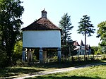
Dovecote

.JPG)


.JPG)
Economy and Infrastructure

Ribagnac is located in the AOC areas of Bergerac with the appellations Bergerac (blanc, rosé, rouge) and Côtes de Bergerac (blanc, rouge) .

total = 43
sport and freetime
- The long-distance hiking trail GR 636 from Monbazillac to Lacapelle-Biron ( Lot-et-Garonne ) also runs through the territory of the municipality.
- The GR 654 long-distance hiking trail from Namur in Belgium via Vézelay to Saint-Jean-Pied-de-Port , together with the GR 636, passes Ribagnac. It follows the Via Lemovicensis, one of the four Camino de Santiago in France.
traffic
Ribagnac can be reached from Monbazillac on Route départementale 13.
Route départementale 107 crosses the territory of the municipality from north to south and connects Ribagnac in the north with Route départementale 933, the former Route nationale 133 , in the south with the neighboring municipality of Sadillac.

Personalities
Charles de Foucauld , full name Charles Eugène Vicomte de Foucauld de Pontbriand, born September 15, 1858 in Strasbourg , died December 1, 1916 in Tamanrasset ( Algeria ), was a researcher, officer , priest , monk and hermit . He lived for a time at Bridoire Castle.
Web links
- Ribagnac on the Pays de Bergerac Tourisme website (French)
- Ribagnac on the Association of Municipalities website (French)
- Information about Bergerac wines
- Bridoire Castle website (French)
Individual evidence
- ↑ Le nom occitan des communes du Périgord ( fr ) Départementrat des Dordogne. Retrieved December 21, 2018.
- ↑ Dordogne ( fr ) habitants.fr. Retrieved December 21, 2018.
- ↑ Aire urbaine de Bergerac (109) ( fr ) INSEE . Retrieved December 21, 2018.
- ↑ Ma commune: Ribagnac ( fr ) Système d'Information sur l'Eau du Bassin Adour Garonne. Retrieved December 21, 2018.
- ↑ Ribagnac ( fr ) Regional Council d'Aquitaine. Archived from the original on September 9, 2016. Retrieved December 21, 2018.
- ^ Paul Vicomte de Gourgues: Dictionnaire topographique du département de la Dordogne ( fr ) In: Dictionnaire topographique de la France . Imprimerie nationale. P. 268, 1873. Retrieved December 21, 2018.
- ^ A b France 1750 ( en ) David Rumsey Map Collection: Cartography Associates. Retrieved December 21, 2018.
- ↑ a b Notice Communale Ribagnac ( fr ) EHESS . Retrieved December 21, 2018.
- ^ Paul Vicomte de Gourgues: Dictionnaire topographique du département de la Dordogne ( fr ) In: Dictionnaire topographique de la France . Imprimerie nationale. P. 43, 1873. Retrieved December 21, 2018.
- ↑ Populations légales 2006 Commune de Ribagnac (24351) ( fr ) INSEE . Retrieved December 21, 2018.
- ↑ Populations légales 2015 Commune de Ribagnac (24351) ( fr ) INSEE . Retrieved December 21, 2018.
- ↑ a b c Mairie de Ribagnac ( fr ) Pays de Bergerac Tourisme. Retrieved December 21, 2018.
- ^ Domaine du Château de Bridoire ( fr ) Ministry of Culture and Communication . September 22, 2015. Accessed December 21, 2018.
- ↑ Château de Bridoire ( fr ) chateau-fort-manoir-chateau.eu. Retrieved December 21, 2018.
- ↑ Institut national de l'origine et de la qualité: Rechercher un produit ( fr ) Institut national de l'origine et de la qualité . Retrieved December 21, 2018.
- ↑ Caractéristiques des établissements en 2015 Commune de Ribagnac (24351) ( fr ) INSEE . Retrieved December 21, 2018.
- ↑ GR636 - Randonnée de Monbazillac (Dordogne) à Lacapelle-Biron (Lot-et-Garonne) ( fr ) gr-infos.com. Retrieved December 21, 2018.
- ↑ La voie de Vézelay ( fr ) Agence de Coopération Interrégionale et Réseau “Chemins de Saint-Jacques de Compostelle”. Retrieved December 21, 2018.
- ↑ CV . Communities Charles de Foucauld. Retrieved December 22, 2018.