Bosset (Dordogne)
| Bosset | ||
|---|---|---|

|
|
|
| region | Nouvelle-Aquitaine | |
| Department | Dordogne | |
| Arrondissement | Bergerac | |
| Canton | Pays de la Force | |
| Community association | Communauté d'agglomération Bergeracoise | |
| Coordinates | 44 ° 57 ' N , 0 ° 21' E | |
| height | 69-146 m | |
| surface | 14.52 km 2 | |
| Residents | 215 (January 1, 2017) | |
| Population density | 15 inhabitants / km 2 | |
| Post Code | 24130 | |
| INSEE code | 24051 | |
 Look at Bosset |
||
Bosset is a French municipality with 215 inhabitants (at January 1, 2017) in the department of Dordogne in the region Nouvelle-Aquitaine (before 2016: Aquitaine ). The municipality belongs to the Arrondissement Bergerac and the canton Pays de la Force (until 2015: canton La Force ).
The name in the Occitan language is Bòsc sec . It is derived from the Latin bos siccus ( German dry tree ).
The inhabitants are called Bossetois and Bossetoises .
geography
Bosset is about 15 km northwest and thus in the catchment area ( Aire urbaine ) of Bergerac in the Landais region of the historic province of Périgord .
Bosset is surrounded by the neighboring communities:
| Saint-Géry | Les Lèches | |

|
||
| Fraisse | Saint-Georges-Blancaneix | Lunas |
Bosset lies in the catchment area of the Dordogne river .
The Lidoire , a right tributary of the Dordogne, has its source in Bosset. The Ruisseau du Vert, a tributary of the Eyraud, also irrigates the area of the municipality.
Today 50% of the municipality is covered with forest.
history
The Bosset parish was first mentioned in the 13th century. During the French Revolution in 1792 the parish priest called de Falgère fled to Spain in order not to become unfaithful to himself. A few years later he crossed the border again to die in his village in 1826. Up until World War I , Bosset was known for its cattle market, which was held on the first Tuesday in February, March, April, May and September. All areas of the village were used for this purpose: the schoolyard for cattle of the Limousin and Blonde d'Aquitaine races , which came from the valleys of the Dronne and the Isle , the village square next to today's grocery store for sheep. Pigs were traded on the road towards Lunas, the other traders had their stalls along the cemetery. At the beginning of the 20th century, the area of the municipality was mainly interspersed with vineyards, which subsequently disappeared due to the phylloxera infestation .
Toponymy
Toponyms and mentions of Bosset were:
- Borses (1286, church records from the 13th century),
- Boscus Siccus (1382, written by Pierre des Mortiers),
- Podium voc. Beausset (1466, Collection de l'abbé de Lespine ),
- Bosseq (1677, notaries from Bergerac),
- Beaucé (1734, register of parishes),
- Bossuet (1744, notaries from Bergerac),
- Bosset (1750, 1793 and 1801, map by Cassini , Notice Communale and Bulletin des Lois, respectively ).
coat of arms
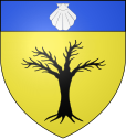
The coat of arms can be interpreted as follows. The dry tree stands for the origin of the name of the community, the scallop shell indicates the patron saint of the community, the apostle James the Elder .
Population development
After records began, the population rose to a peak of 565 in the first half of the 19th century. In the following period, the size of the community fell with relatively short recovery phases until the 1960s to a level of around 200 inhabitants, which has remained until today becomes.
| year | 1962 | 1968 | 1975 | 1982 | 1990 | 1999 | 2006 | 2010 | 2017 |
|---|---|---|---|---|---|---|---|---|---|
| Residents | 216 | 204 | 199 | 182 | 209 | 206 | 202 | 199 | 215 |
Town twinning
Bosset has had a town partnership with Santibáñez de Valcorba in the autonomous region of Castile and León in Spain since 2018 .
Attractions
Parish Church of Saint-Jacques
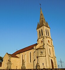
Today's church, consecrated to the Apostle James the Elder, was originally built in the Romanesque style and was restored in the neo-Gothic style in the 19th century . It has a nave with two aisles , a transept and a semicircular apse . Access is via a vestibule, above which a multi-storey bell tower with a helmet rises. The church is located on one of the side routes of the pilgrimage routes to Santiago de Compostela .
Economy and Infrastructure
There are numerous holiday homes and a hotel restaurant in Bosset. Trade and crafts represent important economic factors in the community. Agriculture is shaped u. a. through poultry farming and the production of goat cheese.

Total = 29
sport and freetime
The Boucle de Bosset circular route is 4.7 km long with a difference in altitude of 45 m. It leads from the center through the area of the municipality.
traffic
Bosset is crossed by Route départementale 16, which connects the municipality with Les Lèches in the north and Saint-Georges-Blancaneix in the south.
Web links
- Bosset on the Pays de Bergerac Tourisme website (French)
- Bosset on the association's website (French)
Individual evidence
- ↑ a b c d Bosset ( fr ) Conseil régional d'Aquitaine. Archived from the original on September 9, 2016. Retrieved October 4, 2018.
- ↑ fiche commune BOISSE ( fr ) L'Union des mayors de la Dordogne. Retrieved October 4, 2018.
- ^ Ma commune: Bosset ( fr ) Système d'Information sur l'Eau du Bassin Adour Garonne. Retrieved October 4, 2018.
- ↑ Mairie de Bosset ( fr ) Pays de Bergerac. Retrieved October 4, 2018.
- ^ Paul Vicomte de Gourgues: Dictionnaire topographique du département de la Dordogne ( fr ) In: Dictionnaire topographique de la France . Imprimerie nationale. P. 34, 1873. Retrieved October 4, 2018.
- ^ France 1750 ( en ) David Rumsey Map Collection: Cartography Associates. Retrieved October 4, 2018.
- ↑ a b Notice Communale Bosset ( fr ) EHESS . Retrieved October 4, 2018.
- ↑ Populations légales 2015 Commune de Bosset (24051) ( fr ) INSEE . Retrieved October 4, 2018.
- ↑ Santibáñez de Valcorba (España) ( es ) Retrieved October 4, 2018.
- ^ Eglise Saint-Jacques-le-Majeur ( fr ) Observatoire du patrimoine religieux. Retrieved October 4, 2018.
- ↑ Mairie de Bosset ( fr ) Pays de Bergerac. Retrieved October 4, 2018.
- ↑ Caractéristiques des établissements en 2015 Commune de Bosset (24051) ( fr ) INSEE . Retrieved October 4, 2018.
- ^ Boucle de Bosset ( fr ) Institut national de l'information géographique et forestière (IGN). May 2, 2018. Retrieved October 4, 2018.


