
Conne-de-Labarde
| Conne-de-Labarde | ||
|---|---|---|

|
|
|
| region | Nouvelle-Aquitaine | |
| Department | Dordogne | |
| Arrondissement | Bergerac | |
| Canton | Sud-Bergeracois | |
| Community association | Communes de Portes Sud Périgord | |
| Coordinates | 44 ° 47 ' N , 0 ° 33' E | |
| height | 47-134 m | |
| surface | 10.05 km 2 | |
| Residents | 246 (January 1, 2017) | |
| Population density | 24 inhabitants / km 2 | |
| Post Code | 24560 | |
| INSEE code | 24132 | |
 View of the center of Conne-de-Labarde |
||

Conne-de-Labarde is a French commune of 246 inhabitants (at January 1, 2017) in the department of Dordogne in the region Nouvelle-Aquitaine (before 2016: Aquitaine ). The municipality belongs to the Arrondissement Bergerac and the canton Sud-Bergeracois (until 2015: canton Issigeac ).
The name in the Occitan language is Còmna de la Barda . The first part of the name indicates the geographical location on the banks of the Conne, whose name probably goes back to the ancient Celtic "° kon". The part of the name "barda" comes from Occitan and means "muddy", another reference to the location of the community.
geography
Conne-de-Labarde is about 10 km southeast and thus in the catchment area ( Aire urbaine ) of Bergerac in the Bergeracois region of the historic province of Périgord .
Conne-de-Labarde is surrounded by the neighboring communities:
| Saint-Nexans | ||
| Colombier |
.svg)
|
Saint-Aubin-de-Lanquais |
| Bouniagues | Saint-Cernin-de-Labarde |
Conne-de-Labarde lies in the catchment area of the Dordogne river .
The Conne, a tributary of the Dordogne, crosses the territory of the commune, as does its tributaries, the Ruisseau des Bois, which rises in Conne-de-Labarde, and the Cavérieu.
history
Relics from prehistory and from the Gallo-Roman period that were found in the area of the municipality suggest an early and continuous settlement. In particular, a Gallic ax was found near a dolmen that was used as a sacrificial site. In the 14th century, the three parishes of La Barde, Conne and Saint-Cernin formed a haven for nobles. The water had a certain importance for the development of the community, because in addition to the location on both sides of the Conne, there are no fewer than nine springs in Conne-de-Labarde:
- Fontaine du Bourg
- Fontaine du Bois de Pourquié
- Fontaines des Bayles (2)
- Fontaine de Laudogne
- Fontaine de Malamort
- Fontaine de Soulbarède
- Fontaine des Verdots
- Fontaine de la Fusterie.
Toponymy
Toponyms and mentions of Conne-de-Labarde were:
- Campna (1385, Collection de l'abbé de Lespine ),
- Compne (Périgord Castle , Pau Archives ),
- Conne de la Barde (1750, map by Cassini ),
- Conne Labarde (1793, Notice Communale ),
- Conne-de-la-Barde (1801, Bulletin des Lois ),
- Cone-de-la-Barde (1873, Dictionnaire topographique de la France),
- Conne-de-Labarde (1985).
Population development
After the records began, the population rose in the middle of the 19th century and to a high of around 605. In the following period, the size of the community fell to around 130 inhabitants with relatively short recovery phases until the 1970s, before a moderate growth phase began. that continues today.
| year | 1962 | 1968 | 1975 | 1982 | 1990 | 1999 | 2006 | 2010 | 2017 |
|---|---|---|---|---|---|---|---|---|---|
| Residents | 217 | 190 | 132 | 141 | 191 | 204 | 215 | 227 | 246 |

Attractions
Parish Church of Saint-Laurent-et-Saint-Martin

The church dedicated to Saints Martin of Tours and Lawrence of Rome was built in the 12th century. It is located in the center of the municipality, surrounded by other buildings and to the south by a wooded property, so that only the bell tower is visible from afar . The east- facing apse has retained its Romanesque character. On one of the cornices there are still sculptures in the shape of animals, which over time have gotten into pretty bad shape. The nave with a nave was rebuilt during the Renaissance in the 16th century. It is equipped with a vault and ends in a narrower choir . Two side chapels complete the ensemble, one is dedicated to Mary and the other to Joseph of Nazareth . In 1860 the church with the bell tower and the interior was completely restored. It has been registered as a Monument historique since January 28, 2013 .

Entrance portal

Okulus above the entrance portal
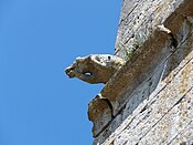
Sculpture on the outer facade

Sculpture on the outer facade


Peyrelevade Castle
The Larroque family had the permanent house built at the beginning of the 16th century. It has a rectangular floor plan and a square tower from the century it was built. It was rebuilt several times during the Renaissance and in 1691 the Sieur de Soubzmaigne had a chapel built on the side. Despite the multiple changes, the original provision is still recognizable for defense purposes. Part of the building has collapsed, the rest has been restored and shows the architectural elements characteristic of the Périgord. The castle is privately owned and is not open to the public.
Economy and Infrastructure

Viticulture is one of the most important economic factors in the municipality.
Conne-de-Labarde is located in the AOC des Bergerac with the appellations Bergerac and Côtes de Bergerac as well as the Noix du Périgord , the walnuts of the Périgord, and the nut oil of the Périgord.

total = 28
sport and freetime
- The GR 6 long-distance hiking trail from Sainte-Foy-la-Grande ( Gironde department ) to Saint-Paul-sur-Ubaye ( Alpes-de-Haute-Provence department ) passes the center of Colombier.
- The Boucle de la Vallée - Conne de Labarde circular route is 6.6 km long with a difference in altitude of 69 m. It leads from the center through the area of the municipality past springs and former water mills.
- The Boucle de Campna - Conne de Labarde circular route is 4.3 km long with a difference in altitude of 34 m. It leads from the center through the area of the municipality past vineyards.
traffic
The Route départementale 14 crosses the territory of the municipality and connects them to the west to the Route Nationale 21 . This leads from Bergerac in the north to Villeneuve-sur-Lot in the neighboring department of Lot-et-Garonne . The D14 also connects Conne-de-Labarde in the southeast with Issigeac , the capital of the former canton of the same name. In the north and east, Conne-de-Labarde is connected to Route départementales 14E2 and 19 and 21 via secondary roads.
Web links
- Conne-de-Labarde on the Pays de Bergerac Tourisme website (French)
- Conne-de-Labarde on the Association of Municipalities website (French)
- Information about Bergerac wines
- Information on Périgord walnuts and Périgord nut oil (French)
Individual evidence
- ↑ Le nom occitan des communes du Périgord ( fr ) Départementrat des Dordogne. Retrieved October 20, 2018.
- ↑ a b Conne-de-Labarde ( fr ) Conseil régional d'Aquitaine. Archived from the original on September 13, 2016. Retrieved October 20, 2018.
- ↑ Ma commune: Conne-de-Labarde ( fr ) Système d'Information sur l'Eau du Bassin Adour Garonne. Retrieved October 20, 2018.
- ↑ a b Mairie de Conne de Labarde ( fr ) Pays de Bergerac Tourisme. Retrieved October 20, 2018.
- ^ Paul Vicomte de Gourgues: Dictionnaire topographique du département de la Dordogne ( fr ) In: Dictionnaire topographique de la France . Imprimerie nationale. P. 85, 1873. Retrieved October 20, 2018.
- ^ France 1750 ( en ) David Rumsey Map Collection: Cartography Associates. Retrieved October 20, 2018.
- ↑ a b Notice Communale Conne-de-Labarde ( fr ) EHESS . Retrieved October 20, 2018.
- ↑ Populations légales 2006 Commune de Conne-de-Labarde (24132) ( fr ) INSEE . Retrieved October 20, 2018.
- ↑ Populations légales 2015 Commune de Conne-de-Labarde (24132) ( fr ) INSEE . Retrieved October 20, 2018.
- ^ Eglise Saint-Laurent et Saint-Martin ( fr ) Ministry of Culture and Communication . September 22, 2015. Accessed October 20, 2018.
- ↑ Château de Peyrelevade ( fr ) chateau-fort-manoir-chateau.eu. Retrieved October 20, 2018.
- ↑ Institut national de l'origine et de la qualité: Rechercher un produit ( fr ) Institut national de l'origine et de la qualité . Retrieved November 30, 2018.
- ↑ Caractéristiques des établissements en 2015 Commune de Conne-de-Labarde (24132) ( fr ) INSEE . Retrieved October 20, 2018.
- ↑ GR6 - Randonnée de Ste Foy-la-Grande (Gironde) à Eyzies-de-Tayac-Sireuil (Dordogne) ( fr ) gr-infos.com. Retrieved October 20, 2018.
- ↑ Boucle de la Vallée - Conne de Labarde ( fr ) Institut national de l'information geographique et forestière (IGN). April 18, 2018. Retrieved October 20, 2018.
- ↑ Boucle de Campna - Conne de Labarde ( fr ) Institut national de l'information geographique et forestière (IGN). April 18, 2018. Retrieved October 20, 2018.