Sainte-Foy-la-Grande
| Sainte-Foy-la-Grande | ||
|---|---|---|

|
|
|
| region | Nouvelle-Aquitaine | |
| Department | Gironde | |
| Arrondissement | Libourne | |
| Canton | Le Réolais and Les Bastides | |
| Community association | Pays Foyen | |
| Coordinates | 44 ° 50 ′ N , 0 ° 13 ′ E | |
| height | 7-20 m | |
| surface | 0.51 km 2 | |
| Residents | 2,554 (January 1, 2017) | |
| Population density | 5,008 inhabitants / km 2 | |
| Post Code | 33220 | |
| INSEE code | 33402 | |
| Website | Sainte-Foy-la-Grande | |
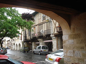
 Market place with arcades |
||
Sainte-Foy-la-Grande is a French commune with 2,554 inhabitants (at January 1, 2017) on the Dordogne in the Gironde department in the region Nouvelle-Aquitaine . The city is located about 50 km east of Bordeaux . It belongs to the canton of Le Réolais et Les Bastides .
Sainte-Foy-la-Grande is on the Bordeaux - Bergerac railway line .
history
Sainte-Foy-la-Grande was built as a typical checkerboard bastide on July 16, 1255 by Alfons of Poitiers (1220-1271), Count of Toulouse and brother of the French King Louis IX. , of the saint. Sainte-Foy-la-Grande converted to Protestantism in 1541 and remained a spiritual center of Calvinism for a long time .
Population development
| year | 1962 | 1968 | 1975 | 1982 | 1990 | 1999 | 2007 | 2017 |
| Residents | 3152 | 3186 | 3345 | 2967 | 2745 | 2788 | 2560 | 2554 |
| Sources: Cassini and INSEE | ||||||||
Architectural monuments
See: List of Monuments historiques in Sainte-Foy-la-Grande
Personalities
- Louis Pierre Gratiolet (1815–1865), doctor and zoologist
- Paul Broca (1824–1880), anthropologist and doctor
- Élisée Reclus (1830–1905), geographer and anarchist
- Elisée Bouny (1872–1900), physician and physiologist
- Élie Faure (1873–1937), art historian and essayist
Community partnerships
- Rotenburg (Wümme) district , Lower Saxony, Germany (since 1973)
- Berthierville , Québec , Canada (since 1983)
literature
- Le Patrimoine des Communes de la Gironde. Flohic Éditions, Volume 2, Paris 2001, ISBN 2-84234-125-2 , pp. 1459-1469.
Web links
Commons : Sainte-Foy-la-Grande - Collection of images, videos and audio files
