Saint-André-et-Appelles
|
Saint-André-et-Appelles Sant Andrieu e Apèla |
||
|---|---|---|

|
|
|
| region | Nouvelle-Aquitaine | |
| Department | Gironde | |
| Arrondissement | Libourne | |
| Canton | Le Réolais and Les Bastides | |
| Community association | Pays Foyen | |
| Coordinates | 44 ° 49 ′ N , 0 ° 12 ′ E | |
| height | 7-114 m | |
| surface | 10.25 km 2 | |
| Residents | 686 (January 1, 2017) | |
| Population density | 67 inhabitants / km 2 | |
| Post Code | 33220 | |
| INSEE code | 33369 | |
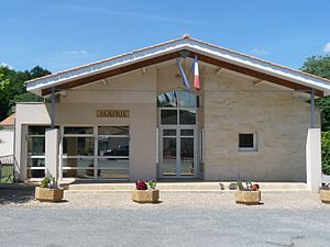
 Town hall (Mairie) of Saint-André-et-Appelles |
||
Saint-André-et-Appelles ( Occitan : Sant Andrieu e Apela ) is a French municipality with 686 inhabitants (as of January 1 2017) in the department of Gironde in the region Nouvelle-Aquitaine . The municipality belongs to the Arrondissement of Libourne and the canton of Le Réolais et Les Bastides (until 2015: canton of Sainte-Foy-la-Grande ). The inhabitants are called Pineuilhais .
geography
Saint-André-et-Appelles is about 17 kilometers west of Bergerac . The Dordogne limits the municipality to the north. Saint-André-et-Appelles is surrounded by the neighboring communities of Port-Sainte-Foy-et-Ponchapt in the north and northeast, Pineuilh in the east and northeast, La Roquille in the southeast, Les Lèves-et-Thoumeyragues in the south, Saint-Quentin- de-Caplong in the southwest and Eynesse in the west and northwest.
Population development
| year | 1962 | 1968 | 1975 | 1982 | 1990 | 1999 | 2006 | 2017 |
| Residents | 527 | 532 | 583 | 607 | 667 | 686 | 676 | 686 |
| Sources: Cassini and INSEE | ||||||||
Attractions
- Church Saint-André from the 16th century
- Chapel of Appelles
Parish partnership
There is a partnership with the Belgian town of Tourpes in the municipality of Leuze-en-Hainaut in Wallonia.
literature
- Le Patrimoine des Communes de la Gironde. Flohic Éditions, Volume 2, Paris 2001, ISBN 2-84234-125-2 , pp. 1451-1453.

