
Saint-Genès-de-Castillon
| Saint-Genès-de-Castillon | ||
|---|---|---|
|
||
| region | Nouvelle-Aquitaine | |
| Department | Gironde | |
| Arrondissement | Libourne | |
| Canton | Les Coteaux de Dordogne | |
| Community association | Grand Saint-Emilionnais | |
| Coordinates | 44 ° 54 ' N , 0 ° 4' E | |
| height | 32-98 m | |
| surface | 6.8 km 2 | |
| Residents | 393 (January 1, 2017) | |
| Population density | 58 inhabitants / km 2 | |
| Post Code | 33350 | |
| INSEE code | 33406 | |
.jpg) Town hall (Mairie) of Saint-Genès-de-Castillon |
||

Saint-Genès-de-Castillon is a French village with 393 inhabitants (as of January 1 2017) in the Gironde department in the region Nouvelle-Aquitaine (before 2016 Aquitaine ); it belongs to the Arrondissement of Libourne and the canton of Les Coteaux de Dordogne (until 2015 Castillon-la-Bataille ). The inhabitants are called Saint-Genésiens .
geography
Saint-Genès-de-Castillon is about 50 kilometers east of Bordeaux . Saint-Genès-de-Castillon is surrounded by the neighboring communities of Puisseguin in the north, Saint-Philippe-d'Aiguille in the northeast, Gardegan-et-Tourtirac in the east, Sainte-Colombe in the south, and Saint-Étienne-de-Lisse in the west Southwest and Montagne in the west and northwest.
Population development
| year | 1962 | 1968 | 1975 | 1982 | 1990 | 1999 | 2006 | 2017 |
| Residents | 378 | 454 | 398 | 402 | 370 | 389 | 377 | 393 |
| Sources: Cassini and INSEE | ||||||||
Attractions
- 19th century church
- Flojague Castle from the 16th century
- L'Estang Castle
- La Jarousse Castle
- Gravoux mansion from the 14th / 15th centuries Century ( Monument historique )

Saint-Genès church
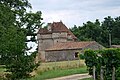
Gravoux manor
.JPG)

literature
- Le Patrimoine des Communes de la Gironde. Flohic Éditions, Volume 1, Paris 2001, ISBN 2-84234-125-2 , p. 580.
Web links
Commons : Saint-Genès-de-Castillon - Collection of images, videos and audio files