
Mouliets-et-Villemartin
| Mouliets-et-Villemartin | ||
|---|---|---|
|
||
| region | Nouvelle-Aquitaine | |
| Department | Gironde | |
| Arrondissement | Libourne | |
| Canton | Les Coteaux de Dordogne | |
| Community association | Castillon-Pujols | |
| Coordinates | 44 ° 51 ′ N , 0 ° 1 ′ E | |
| height | 2-93 m | |
| surface | 15.91 km 2 | |
| Residents | 1,061 (January 1, 2017) | |
| Population density | 67 inhabitants / km 2 | |
| Post Code | 33350 | |
| INSEE code | 33296 | |
 Town hall (Mairie) of Mouliets-et-Villemartin |
||

Mouliets-et-Villemartin is a French village with 1,061 inhabitants (as of January 1 2017) in the Gironde department in the region Nouvelle-Aquitaine (before 2016 Aquitaine ); it belongs to the Arrondissement Libourne and the canton Les Coteaux de Dordogne (until 2015 Pujols ). The inhabitants are called Moulietsois .
geography
Mouliets-et-Villemartin is located about 48 kilometers east of Bordeaux on the Dordogne , which borders the municipality in the north. Mouliets-et-Villemartin is surrounded by the neighboring communities of Castillon-la-Bataille in the north and northwest, Lamothe-Montravel in the north and northeast, Flaujagues in the east, Sainte-Radegonde in the southeast, Pujols in the south, and Saint-Pey-de-Castets in the West and south-west as well as Saint-Magne-de-Castillon to the west.
Population development
| year | 1962 | 1968 | 1975 | 1982 | 1990 | 1999 | 2006 | 2017 |
| Residents | 679 | 743 | 724 | 801 | 915 | 1.009 | 1,046 | 1061 |
| Sources: Cassini and INSEE | ||||||||
Attractions
- Saint-Martin church from 11th / 12th centuries Century, since 2001 Monument historique
- Saint-Ferdinand church in Pique-Sègue
- Ruins of the chapel of Villemartin
See also: List of Monuments historiques in Mouliets-et-Villemartin
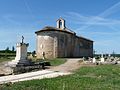
Saint Martin Church

Saint Ferdinand Church
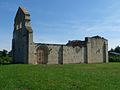
Chapel of Villemartin


literature
- Le Patrimoine des Communes de la Gironde. Flohic Éditions, Volume 2, Paris 2001, ISBN 2-84234-125-2 , pp. 1171–1172.