
Pujols (Gironde)
|
Pujols Pujòus |
||
|---|---|---|
.svg)
|
|
|
| region | Nouvelle-Aquitaine | |
| Department | Gironde | |
| Arrondissement | Libourne | |
| Canton | Les Coteaux de Dordogne | |
| Community association | Castillon-Pujols | |
| Coordinates | 44 ° 48 ′ N , 0 ° 2 ′ W | |
| height | 9-98 m | |
| surface | 7.4 km 2 | |
| Residents | 538 (January 1, 2017) | |
| Population density | 73 inhabitants / km 2 | |
| Post Code | 33350 | |
| INSEE code | 33344 | |
| Website | http://communepujols33.fr/ | |
 Town hall (Mairie) of Pujols in the castle |
||

Pujols ( Occitan : Pujòus ) is a southwestern French community with 538 inhabitants (at January 1, 2017) in the Gironde department in the region Nouvelle-Aquitaine (before 2016: Aquitaine ). The municipality belongs to the Arrondissement of Libourne and the canton of Les Coteaux de Dordogne (until 2015: canton of Pujols ). The inhabitants are called Pujolais .
location
Pujols is located about 43 kilometers east of Bordeaux and about 20 kilometers southeast of Libourne in the Dordogne valley . Pujols is surrounded by the neighboring municipalities of Mouliets-et-Villemartin in the north, Doulezon in the east and southeast, Ruch in the south, Bossugan in the southwest and Saint-Pey-de-Castets in the west.
Population development
| year | 1962 | 1968 | 1975 | 1982 | 1990 | 1999 | 2006 | 2017 |
| Residents | 580 | 534 | 465 | 517 | 573 | 604 | 580 | 538 |
| Sources: Cassini and INSEE | ||||||||
Attractions
- Saint-Pierre church from the 13th / 14th centuries Century, Monument historique since 1846
- Castle from the 14th / 15th centuries Century, Monument historique since 1925
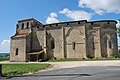
Saint-Pierre church
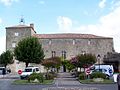
Pujols Castle


Personalities
- Charles Platon (1886–1944), admiral, politician, member of the Vichy regime as State Secretary
literature
- Le Patrimoine des Communes de la Gironde. Flohic Éditions, Volume 2, Paris 2001, ISBN 2-84234-125-2 , pp. 1176–1179.
Web links
Commons : Pujols - collection of images, videos and audio files