
Vérac
|
Vérac Vairac |
||
|---|---|---|
|
||
| region | Nouvelle-Aquitaine | |
| Department | Gironde | |
| Arrondissement | Libourne | |
| Canton | Le Libournais-Fronsadais | |
| Community association | Fronsadais | |
| Coordinates | 45 ° 0 ′ N , 0 ° 20 ′ W | |
| height | 11-69 m | |
| surface | 8.59 km 2 | |
| Residents | 923 (January 1, 2017) | |
| Population density | 107 inhabitants / km 2 | |
| Post Code | 33240 | |
| INSEE code | 33542 | |
 Town hall (Mairie) of Vérac |
||

Vérac ( Occitan : Vairac ) is a southwestern French community with 923 inhabitants (as of January 1 2017) in the department of Gironde in the region Nouvelle-Aquitaine . The municipality belongs to the Arrondissement Libourne and the canton Le Libournais-Fronsadais (until 2015: Canton Fronsac ).
location
Vérac is located about 25 kilometers northeast of Bordeaux and about twelve kilometers northwest of Libourne . Vérac is surrounded by the neighboring municipalities of Mouillac and Saint-Genès-de-Fronsac in the north, Périssac in the northeast, Galgon in the east, Villegouge in the south and southeast, Tarnès in the southwest, La Lande-de-Fronsac in the west and Salignac in the northwest.
Population development
| year | 1962 | 1968 | 1975 | 1982 | 1990 | 1999 | 2006 | 2017 |
| Residents | 510 | 550 | 465 | 581 | 656 | 715 | 776 | 923 |
| Sources: Cassini and INSEE | ||||||||
Attractions
- Saint-Cybard church from the 12th century
- Pommiers Castle
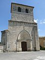
Saint-Cybard Church
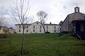
Pommiers Castle


literature
- Le Patrimoine des Communes de la Gironde. Flohic Éditions, Volume 1, Paris 2001, ISBN 2-84234-125-2 , p. 724.
Web links
Commons : Vérac - collection of images, videos and audio files