Saint-Romain-de-Monpazier
| Saint-Romain-de-Monpazier | ||
|---|---|---|
|
|
||
| region | Nouvelle-Aquitaine | |
| Department | Dordogne | |
| Arrondissement | Bergerac | |
| Canton | Lalinde | |
| Community association | Communes des Bastides Dordogne-Périgord | |
| Coordinates | 44 ° 43 ' N , 0 ° 52' E | |
| height | 116-227 m | |
| surface | 7.48 km 2 | |
| Residents | 110 (January 1, 2017) | |
| Population density | 15 inhabitants / km 2 | |
| Post Code | 24540 | |
| INSEE code | 24495 | |
 Town hall ( Mairie ) of Saint-Romain-de-Monpazier |
||
Saint-Romain-de-Monpazier is a French municipality with 110 inhabitants (at January 1, 2017) in the department of Dordogne in the region Nouvelle-Aquitaine (before 2016: Aquitaine ). The municipality belongs to the arrondissement Bergerac and the canton Lalinde (until 2015: canton Monpazier ).
The name in the Occitan language is Sent Róman de Mont Pasièr and is derived from Saint Romanus of Rome .
The inhabitants are called Saint-Rominois and Saint-Rominoises .
geography
Saint-Romain-de-Monpazier is located approx. 35 km southeast of Bergerac in the Bergeracois area of the historic province of Périgord on the southern edge of the department.
Saint-Romain-de-Monpazier is surrounded by the six neighboring municipalities:
| Sainte-Croix | Montferrand-du-Périgord | Saint-Avit-Rivière |

|
Saint-Marcory | |
| Lolme | Marsals |
Saint-Romain-de-Monpazier is located in the catchment area of the Dordogne river . The Véronne, a tributary of the Couze , marks the border to the south-western neighboring municipality of Lolme.
Population development
After the records began, the number of inhabitants rose to a high of 400 in the middle of the 19th century. In the period that followed, a phase of stagnation set in until the 1970s, which caused the number of inhabitants to drop to around 60 with short recovery phases. before a growth phase began that continues to this day.
| year | 1962 | 1968 | 1975 | 1982 | 1990 | 1999 | 2006 | 2011 | 2017 |
|---|---|---|---|---|---|---|---|---|---|
| Residents | 91 | 72 | 62 | 67 | 78 | 91 | 80 | 88 | 110 |
Attractions
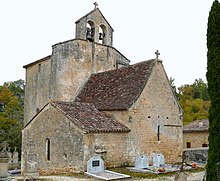
- Church Saint-Romain from the 12th century, when monument historique enrolled
Economy and Infrastructure
Saint-Romain-de-Monpazier is located in the AOC zones of the Noix du Périgord , the walnuts of the Périgord, and the nut oil of the Périgord.

total = 13
traffic
Saint-Romain-de-Monpazier can be reached via Routes départementales 2 and 26E.
Web links
Individual evidence
- ↑ Le nom occitan des communes du Périgord ( fr ) Départementrat des Dordogne. Retrieved January 18, 2019.
- ↑ Elysée Cerou: La commune de Saint-Romain ( fr , PDF) Groupe Archéologique Mons-Paciarus. 1993. Retrieved January 18, 2019.
- ↑ Saint-Romain-de-Monpazier ( fr ) Conseil régional d'Aquitaine. Archived from the original on September 9, 2016. Retrieved January 18, 2019.
- ↑ Ma commune: Saint-Romain-de-Monpazier ( fr ) Système d'Information sur l'Eau du Bassin Adour Garonne. Retrieved January 18, 2019.
- ↑ Notice Communale Saint-Romain-de-Monpazier ( fr ) EHESS . Retrieved January 18, 2019.
- ↑ Populations légales 2016 Commune de Saint-Romain-de-Monpazier (24495) ( fr ) INSEE . Retrieved January 18, 2019.
- ↑ Institut national de l'origine et de la qualité: Rechercher un produit ( fr ) Institut national de l'origine et de la qualité . Retrieved January 18, 2019.
- ↑ Caractéristiques des établissements en 2015 Commune de Saint-Romain-de-Monpazier (24495) ( fr ) INSEE . Retrieved January 18, 2019.


