
Pomport
| Pomport | ||
|---|---|---|

|
|
|
| region | Nouvelle-Aquitaine | |
| Department | Dordogne | |
| Arrondissement | Bergerac | |
| Canton | Sud-Bergeracois | |
| Community association | Agglomération Bergeracoise | |
| Coordinates | 44 ° 47 ' N , 0 ° 25' E | |
| height | 38-171 m | |
| surface | 19.55 km 2 | |
| Residents | 739 (January 1, 2017) | |
| Population density | 38 inhabitants / km 2 | |
| Post Code | 24240 | |
| INSEE code | 24331 | |
 Former mill |
||

Pomport is a French municipality with 739 inhabitants (at January 1, 2017) in the department of Dordogne in the region Nouvelle-Aquitaine (before 2016: Aquitaine ). The municipality belongs to the Arrondissement Bergerac and the canton Sud-Bergeracois (until 2015: Canton Sigoulès ).
The name in the Occitan language is Pompòrt , about the origin of which there are many different theories. It could go back to the ancient Celtic pomp ( German hill, hill ). The center of Pomport is actually on a hill. Another theory favors the derivation from the Latin words poma ( German fruits of the soil ) and portans ( German bearing ). The cultivation of wine since the Middle Ages could underline this. Due to the location on a pilgrimage route to Santiago de Compostela , a derivation of the Latin portus ( German port ) is also possible. Similar examples of place names on the Way of St. James are Somport and Saint-Jean-Pied-de-Port .
The inhabitants are called Pomportois and Pomportoises .
geography
Pomport is located approx. 10 km southwest in the catchment area ( Aire urbaine ) of Bergerac in the Bergeracois area of the historic province of Périgord on the southern edge of the department.
Pomport is surrounded by the neighboring communities:
| Gageac-et-Rouillac | Lamonzie-Saint-Martin | Saint-Laurent-des-Vignes |
.svg)
|
Monbazillac | |
| Cunèges |
Sigoulès Flaugeac |
Rouffignac-de-Sigoulès |
Pomport is located in the catchment area of the Dordogne river .
The Gardonnette, one of its tributaries, crosses the territory of the commune, as does its tributaries that have their source in Pomport:
- the Courbarieux (water code P5330550),
- the Courbarieux of the same name (water code P5330580) and
- the Ruisseau de la Peyronnette.
history
The vineyards, which are still the basis of economic activity today, were created from 1100 by the monks of Saint-Martin in Bergerac and Labadie in Colombier . The residents of Pomport subsequently increased them. The trade in wine was able to develop through the shipping of the products across the river, because in earlier times there was no other transport connection to the community. The number of pilgrims on the Camino de Santiago increased especially after a fortification was built in Bergerac at the beginning of the 12th century. There was also a priory in Saint-Mayme , which was subordinate to a branch of the Abbey of Saint-Cybard in Angoulême , which was located in Trémolat .
Pomport served the Bergerac castellany as the military headquarters. The fortress of Montcuq, which played a decisive role in the Hundred Years War , was built on the territory of the municipality . Henry of Grosmont, 1st Duke of Lancaster , Earl of Derby , was a lieutenant in the army of the English king. His troops horrified the fortress of Montcuq, which was besieged by troops of the French crown, before he left there on August 24, 1345 to go to the Battle of Bergerac . Montcuq belonged to the Pons and Rudel families, landlords of Bergerac in the 12th and 13th centuries. They lost power in the 14th century. The judicial district of Montcuq was reduced to twelve parishes, and the d'Albret family acquired the right from 1334 to the 16th century. In 1600 Monbazillac became independent and the castellany only included Pomport, Saint-Mayme, Le Monteil and Rouillac. Between 1620 and 1622, Captain Montlong, a vassal of Montcuq, conquered the old fortress in the prevailing disorder between Protestant and royal troops and entrenched himself there. In 1628, by order of Cardinal Richelieu , Montcuq was razed and was only a ruin when it was occupied by the croquants . Gontaut Biron acquired the manor in 1714 through an inheritance. The ruins of the castle were no longer recorded in the register. A fire has meanwhile destroyed the last buildings. In 1777 Montcuq was sold in equal parts to Louis de Brianson, Baron von Perrou, and Hilaire de Fonvielle, Seigneur von Monboucher. At the end of the 19th century, one to one and a half meters high wall remnants could still guess the earlier appearance. The castle complex had an oval shape and extended over an area of 100 meters in length and 30 meters in width. A terrace several meters wide, surrounded by a ditch, led around the plateau. The walls have since been torn down. However, axes made of flint , Roman ceramics and coins have been found here.
When the territories were reorganized during the French Revolution , the parish of Saint-Mayme was incorporated.
Toponymy
Toponyms and mentions of Pomport were:
- Sanctus Petrus de Pomport (1142, copy book of the Abbey of Saint-Cybard),
- Pomporn and Pompornium (1494, collection of the Abbé de Lespine),
- Ponport (1750 and 1793, map by Cassini or Notice Communale ),
- Pomport (1801, Bulletin des Lois ).
Population development
When the records began, the population peaked at 1,385. Subsequently, the size of the community decreased with brief recovery periods up to the 1980s to around 640 residents before a period of growth began that has recently stagnated.
| year | 1962 | 1968 | 1975 | 1982 | 1990 | 1999 | 2006 | 2010 | 2017 |
|---|---|---|---|---|---|---|---|---|---|
| Residents | 868 | 765 | 673 | 641 | 655 | 707 | 769 | 804 | 739 |

Town twinning
Pomport has been twinning with Bréhan in the French department of Morbihan in the Brittany region since 1987 .
Attractions
Saint-Mayme Chapel
The chapel was built in the 12th century and was dependent on the Abbey of Saint-Cybard in Angoulême. It has been destroyed several times over the centuries. Your nave with a nave without a yoke merges into a semicircular choir . The west facade shows an entrance portal in the form of a pressed pointed arch , which is decorated with a simple bead . Above it is a niche with a cross. At the top the facade merges into a bell gable with two openings for the bells. The apse and the west facade with the bell gable have been inscribed as Monument historique since January 15, 1974 .
- Saint-Mayme Chapel

South facade

Bell gable

Entrance portal

Console on the apse
.JPG)

.JPG)
.JPG)
Saint-Pierre-ès-Liens parish church
The originally Romanesque church was destroyed in the Huguenot Wars and rebuilt by the noble Courssou de Caillevel family. The name of the church is derived from the chains with which the Apostle Peter was tied in Rome according to the Acts of the Apostles of Luke . The striking bell tower was built in 1904. With its battlements , it is reminiscent of a square keep . The church contains, among other things, a silver chalice and a silver paten from the 18th century with Latin inscriptions and rich decorations. Since November 9, 1976, they have been classified as movable objects as Monuments historiques .
- Saint-Pierre-ès-Liens parish church

West facade with bell tower

Entrance portal

Nave overlooking the choir

Choir
.jpg)


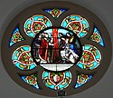
- Stained glass window in the parish church
Rose window

Glass window of the entrance portal

Annunciation of the Lord

Apostle Peter in chains

Dionysius of Alexandria

.jpg)

.jpg)
.jpg)
Bélingard Castle
The Celtic sun god Belin or Beleen is the namesake of the castle, which is now in the seventh generation of a winery. A rock in the shape of a seat has been found on the site and could have been a former sacrificial site.
Malveyran Castle
The building was erected between the 13th and 15th centuries and is located in the center of Pomport.

Pécany Castle
It is the former fief of the Courson and La Mothe families. Samuel de la Mothe, who owned it in 1636, inherited the aristocratic residence from his mother, whose sister had married Antoine de Courson in 1627. The present mansion was built around 1780 by Etienne Escot, who made his fortune as a trader in the Netherlands . The residential wing is adorned by tourelles and flanked by two side wings, the facades of which face the grassland to the south and an inner courtyard to the north, which is surrounded by ancillary buildings. The stone chimneys and numerous portholes are remarkable . The castle is now a winery.

Sanxet Castle
Originally the castle was an English fortress. It has belonged to the same family since the 16th century. A round corner tower and lattice windows embellish the residential wing. On the first floor there is a room with a mosaic floor made of pebbles. In front of the entrance wall, some stone balls from the surrounding fields have been collected, which have been cut by hand. In the 17th century, cellars were created under the castle to establish wine cellars there. The castle is now a winery and has an automobile museum.
Birondie manor
Jeanne-Amélie-Blanche Franc de Ferrière (1859-1940), who later married Pierre Loti , a French naval officer and writer , was born on the old estate.
Caillevel manor house
Today's winery is located south of the center of Pomport and was originally a noble residence. Today it was able to keep its chapel.
Girony manor
The former aristocratic seat is west of the center of Pomport and belonged to the Alba family.
Montlong Manor
Former fiefdom and aristocratic residence. The Seigneur of Mons logus paid homage to the English king in 1273.
Economy and Infrastructure

Viticulture is one of the most important economic factors in the municipality. Wine is grown on 1,200 of the 1,954 hectares in the municipality.
Pomport is located in the AOC areas of Bergerac with the appellations Bergerac (blanc, rosé, rouge) , Côtes de Bergerac (blanc, rouge) and des Monbazillac , a dessert wine .

total = 110
education
The municipality has a public pre-school with 80 students in the 2018/2019 school year.
sport and freetime
- The long-distance hiking trail GR 654 from Namur in Belgium via Vézelay to Saint-Jean-Pied-de-Port leads together with the GR 6 over the northern area of Pomport. It follows the Via Lemovicensis, one of the four Camino de Santiago in France.
- The GR 6 long-distance hiking trail from Sainte-Foy-la-Grande ( Gironde department ) to Saint-Paul-sur-Ubaye ( Alpes-de-Haute-Provence department ) also passes Pomport.
traffic
The Route départementale 14 touches the northern area of the municipality. Route départementale 16 crosses it from north to southwest and connects Pomport in the north with the neighboring municipality of Lamonzie-Saint-Martin on the Bordeaux- Bergerac axis , in the southwest with the neighboring municipality of Cunèges. Route départementale 16 crosses Pomport from south to east and connects the municipality in the south with the neighboring municipality of Sigoulès, the capital of the former canton, and in the east with Route départementale 933, the former Route nationale 133 .
Web links
- Pomport on the Pays de Bergerac Tourisme website (French)
- Pomport on the association's website (French)
- Information about Bergerac wines
- Monbazillac product sheet on the INAO website (French)
- Bélingard Castle website (French)
Individual evidence
- ↑ Le nom occitan des communes du Périgord ( fr ) Départementrat des Dordogne. Retrieved December 18, 2018.
- ↑ a b c Pomport ( fr ) Conseil régional d'Aquitaine. Archived from the original on September 9, 2016. Retrieved December 18, 2018.
- ↑ a b Mairie de Pomport ( fr ) Pays de Bergerac Tourisme. Retrieved December 18, 2018.
- ↑ Dordogne ( fr ) habitants.fr. Retrieved December 18, 2018.
- ↑ Aire urbaine de Bergerac (109) ( fr ) INSEE . Retrieved December 18, 2018.
- ↑ Ma commune: Pomport ( fr ) Système d'Information sur l'Eau du Bassin Adour Garonne. Retrieved December 18, 2018.
- ↑ a b c d e f g h i Mairie de Pomport ( fr ) Pays de Bergerac Tourisme. Retrieved December 18, 2018.
- ^ John A. Wagner: Encyclopedia of the Hundred Years War ( en , PDF) Greenwood Press. P. 52. 2006. Accessed December 18, 2018.
- ↑ a b Paul Vicomte de Gourgues: Dictionnaire topographique du département de la Dordogne ( fr ) In: Dictionnaire topographique de la France . Imprimerie nationale. P. 243. 1873. Retrieved December 18, 2018.
- ↑ a b c Notice Communale Pomport ( fr ) EHESS . Retrieved December 18, 2018.
- ^ France 1750 ( en ) David Rumsey Map Collection: Cartography Associates. Retrieved December 18, 2018.
- ↑ Populations légales 2015 Commune de Pomport (24331) ( fr ) INSEE . Retrieved December 18, 2018.
- ^ Jumelages ( fr ) Bréhan municipality. 2014. Retrieved December 18, 2018.
- ^ Chapelle Saint-Mayne ( fr ) Ministry of Culture and Communication . September 22, 2015. Accessed December 18, 2018.
- ↑ calice, patène ( fr ) Ministry of Culture and Communication . October 7, 1993. Retrieved November 18, 2018.
- ↑ L'histoire de château Bélingard ( fr ) Castle Bélingard. Retrieved December 18, 2018.
- ↑ Château de Pécany ( fr ) chateau-fort-manoir-chateau.eu. Retrieved December 18, 2018.
- ↑ Château de Sanxet ( fr ) chateau-fort-manoir-chateau.eu. Retrieved December 18, 2018.
- ↑ Institut national de l'origine et de la qualité: Rechercher un produit ( fr ) Institut national de l'origine et de la qualité . Retrieved December 18, 2018.
- ↑ Caractéristiques des établissements en 2015 Commune de Pomport (24331) ( fr ) INSEE . Retrieved December 18, 2018.
- ^ École maternelle et élémentaire ( fr ) National Ministry of Education. Retrieved December 18, 2018.
- ↑ La voie de Vézelay ( fr ) Agence de Coopération Interrégionale et Réseau “Chemins de Saint-Jacques de Compostelle”. Retrieved December 18, 2018.
- ↑ GR6 - Randonnée de Ste Foy-la-Grande (Gironde) à Eyzies-de-Tayac-Sireuil (Dordogne) ( fr ) gr-infos.com. Retrieved December 18, 2018.