Molières (Dordogne)
| Molières | ||
|---|---|---|

|
|
|
| region | Nouvelle-Aquitaine | |
| Department | Dordogne | |
| Arrondissement | Bergerac | |
| Canton | Lalinde | |
| Community association | Bastides Dordogne-Périgord | |
| Coordinates | 44 ° 49 ′ N , 0 ° 49 ′ E | |
| height | 65-205 m | |
| surface | 21.22 km 2 | |
| Residents | 330 (January 1, 2017) | |
| Population density | 16 inhabitants / km 2 | |
| Post Code | 24480 | |
| INSEE code | 24273 | |
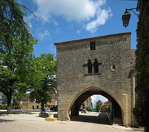
 Molières - central square with the Maison du Bayle in the foreground |
||
Molière is a French commune of 330 inhabitants (at January 1, 2017) in the Dordogne near Cadouin in the region Nouvelle-Aquitaine .
Molières is the smallest bastide in the region and was founded in 1284 by Jean de Grailly on behalf of the English King Edward I with Royal Charter on November 27, 1285. The status granted to the village was confirmed by the French kings Francis I and Henry II in October 1533 and May 1551.
The arcades of the Maison du Bayle are in the square in the center of the village. The church in the main street shows the typical English style of the Plantagenet - Gothic . On the opposite side of the village are the ruins of the Château de Molières with a donjon . Erected in 1316 by Ghilem Toulouse, Seneschal of Périgord, the fortress evidently offered little protection. Molières was devastated in the Hundred Years War , rebuilt and destroyed again during the Wars of Religion . Legend has it that on his return from Spain , Bertrand du Guesclin brought with him the legitimate wife of the King of Castile, Blanche de Bourbon . He had saved her from her husband, Peter I , the Cruel, who wanted to have her arrested so that he could live with his lover. It is not known whether the queen actually stayed here. The castle was popularly called Château de la Reine Blanche .
As early as 1272, Guillaume de Biron, Seigneur of Montferrand-du-Périgord, had donated land in the parish of Saint-Jean-de-Molières to build a bastide. This parish is mentioned in a document from 1115 concerning Cadouin Abbey . However, only a place called Saint-Jean near the cemetery in the north of the village testifies to this primitive first settlement.
Archaeological excavations carried out in the mid-19th century have unearthed a number of Gallo-Roman finds, including a Roman aureus from the time of Nero . In addition, there are paths and roads around the place that were already used in ancient times or were laid out by the Romans.
Population development
On the basis of the tax register from 1365, the late medieval population is estimated at around 1200 inhabitants.
| year | 1962 | 1968 | 1975 | 1982 | 1990 | 1999 | 2009 | 2016 |
| Residents | 358 | 347 | 283 | 294 | 315 | 292 | 319 | 327 |
| Sources: Cassini and INSEE | ||||||||
literature
- Alo Miller, Nikolaus Miller: Dordogne (= DuMont travel paperback. ). DuMont-Reiseverlag, Ostfildern 2005, ISBN 3-7701-6318-4 , p. 197.
Web links
Individual evidence
- ^ Jean-Pierre Leray: Châteaux, bastides, commanderies du Périgord . Pierre Fanlac, Périgueux 1976, p. 38 (French).
