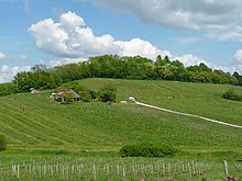
Serres-et-Montguyard
| Serres-et-Montguyard | ||
|---|---|---|
|
|
||
| region | Nouvelle-Aquitaine | |
| Department | Dordogne | |
| Arrondissement | Bergerac | |
| Canton | Sud-Bergeracois | |
| Community association | Communes de Portes Sud Périgord | |
| Coordinates | 44 ° 41 ′ N , 0 ° 27 ′ E | |
| height | 47-129 m | |
| surface | 6.85 km 2 | |
| Residents | 237 (January 1, 2017) | |
| Population density | 35 inhabitants / km 2 | |
| Post Code | 24500 | |
| INSEE code | 24532 | |
| Website | www.serres-et-montguyard.fr | |
 Parish Church of Saint-Pierre-Es-Liens |
||
Serres-et-Montguyard is a French municipality with 237 inhabitants (at January 1, 2017) in the department of Dordogne in the region Nouvelle-Aquitaine (before 2016: Aquitaine ). The municipality belongs to the Arrondissement Bergerac and the canton Sud-Bergeracois (until 2015: canton Eymet ).
The name in the Occitan language is Serras e Mont Guiard . The first part of the name "Serre" goes back to the ancient Celtic word serr ( German mountain, mountain ridge ). The second part of the name means "Mountain of Guiard". "Guiard" has its Germanic origin in the name "Withard".
geography
Serres-et-Montguyard is located about 20 km south of Bergerac in the Bergeracois area of the historic Périgord province on the southern border with the neighboring Lot-et-Garonne department .
Serres-et-Montguyard is surrounded by the five neighboring municipalities:
| Fonroque | Razac-d'Eymet | Saint-Aubin-de-Cadelech |
| Eymet |

|
|
|
Lauzun (Lot-et-Garonne) |
Serres-et-Montguyard lies in the catchment area of the Garonne River . The Dropt , one of its right tributaries, crosses the area of the municipality together with its tributaries,
- the Ruisseau du Pontillou,
- the Marzelou,
- the Payot, which rises in Serres-et-Montguyard, and
- the Ruisseau du Réveillou.
Population development
When records began, the number of inhabitants rose to a peak of around 495 at the beginning of the 19th century. In the period that followed, a phase of stagnation set in until the 1990s, which caused the number of inhabitants to drop to around 140 with short recovery phases before a period of growth began that continues today.
| year | 1962 | 1968 | 1975 | 1982 | 1990 | 1999 | 2006 | 2011 | 2017 |
|---|---|---|---|---|---|---|---|---|---|
| Residents | 238 | 196 | 181 | 151 | 139 | 152 | 181 | 215 | 237 |
Attractions
- Parish church of Saint-Pierre-Es-Liens in Serres, neo-Gothic building from the 19th century
- Chapel of Saint Pierre in Montguyard, Romanesque building from the 13th century
- 18th century mansion La Tour
Economy and Infrastructure
Serres-et-Montguyard is located in the AOC areas of Bergerac with the appellations Bergerac (blanc, rosé, rouge) and Côtes de Bergerac (blanc, rouge) .

total = 22
traffic
Serres-et-Montguyard can be reached via the routes départementales 25 and 107 (266 in the Lot-et-Garonne department).
Web links
- Serres-et-Montguyard on the association's website (French)
- Serres-et-Montguyard on the Eymet municipality website (French)
- Information about Bergerac wines
Individual evidence
- ↑ Le nom occitan des communes du Périgord ( fr ) Départementrat des Dordogne. Retrieved January 21, 2019.
- ↑ Ma commune: Serres-et-Montguyard ( fr ) Système d'Information sur l'Eau du Bassin Adour Garonne. Retrieved January 21, 2019.
- ^ Notice Communale Serres-et-Montguyard ( fr ) EHESS . Retrieved January 21, 2019.
- ↑ Populations légales 2016 Commune de Serres-et-Montguyard (24532) ( fr ) INSEE . Retrieved January 21, 2019.
- ↑ Institut national de l'origine et de la qualité: Rechercher un produit ( fr ) Institut national de l'origine et de la qualité . Retrieved January 21, 2019.
- ↑ Caractéristiques des établissements en 2015 Commune de Serres-et-Montguyard (24532) ( fr ) INSEE . Retrieved January 21, 2019.


