
Saint-Capraise-de-Lalinde
| Saint-Capraise-de-Lalinde | ||
|---|---|---|
|
||
| region | Nouvelle-Aquitaine | |
| Department | Dordogne | |
| Arrondissement | Bergerac | |
| Canton | Lalinde | |
| Community association | Communes des Bastides Dordogne-Périgord | |
| Coordinates | 44 ° 51 ′ N , 0 ° 39 ′ E | |
| height | 18-132 m | |
| surface | 3.83 km 2 | |
| Residents | 531 (January 1, 2017) | |
| Population density | 139 inhabitants / km 2 | |
| Post Code | 24150 | |
| INSEE code | 24382 | |
| Website | www.saint-capraise-de-lalinde.fr | |
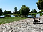
.JPG) View of the center of Saint-Capraise-de-Lalinde on the banks of the Dordogne |
||

Saint-Capraise-de-Lalinde is a French municipality with 531 inhabitants (at January 1, 2017) in the department of Dordogne in the region Nouvelle-Aquitaine (before 2016: Aquitaine ). The municipality belongs to the Arrondissement of Bergerac and the canton of Lalinde .
The name in the Occitan language is Sent Grapasi de la Linda and is derived from St. Caprasius.
The inhabitants are called Capraisiens and Capraisiennes .
geography
Saint-Capraise-de-Lalinde is located approx. 15 km east in the catchment area ( Aire urbaine ) of Bergerac in the Bergeracois area of the historical province of Périgord .
Saint-Capraise-de-Lalinde is surrounded by the neighboring municipalities:
| Cause de Clérans | ||
| Mouleydier |
.svg)
|
Baneuil |
| Saint-Agne | Varennes |
Saint-Capraise-de-Lalinde is located on the right bank of the Dordogne and on the Canal de Lalinde , a side canal of the Dordogne.
Population development
After records began, the number of inhabitants rose to an initial high of around 450 in the middle of the 19th century. At the end of the same century, there was a phase of stagnation with a low of around 290 inhabitants. At the beginning of the 20th century a longer period of growth began, with the population peaking in the 1990s at around 585. Since then, the size of the community has been around 530 inhabitants.
| year | 1962 | 1968 | 1975 | 1982 | 1990 | 1999 | 2006 | 2010 | 2017 |
|---|---|---|---|---|---|---|---|---|---|
| Residents | 460 | 485 | 506 | 555 | 584 | 531 | 554 | 522 | 531 |


Attractions
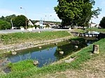
Three locations of the Canal de Lalinde date from the 19th century and are inscribed as Monuments historiques :
- the basin for parking the river boats,
- the dry dock and
- the canal bridge and the neighboring bank structure.
Other attractions are
- the weir of Tuilières between the communes of Saint-Capraise-de-Lalinde and Saint-Agne and
- the parish church of Saint-Caprais of Romanesque origin with a bell gable from the 19th century.
Basin for parking the river boats
Dry dock

Canal bridge
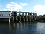
Tuilières dam

Parish Church of Saint-Caprais

.jpg)

.JPG)

Economy and Infrastructure

The geographic location on the river dictates the focus of the municipality's economy on trade, transportation and services. The Tuilières hydropower plant is located in the far west of the municipality.

total = 46
education
The municipality has a public pre-school with 44 students in the 2018/2019 school year.
traffic
.JPG)
Saint-Capraise-de-Lalinde can be reached via Route départementale 660, the former Route nationale 660 , which here forms the Bergerac – Sarlat-la-Canéda axis.
Line 26 of the TER Aquitaine , a regional train of the national SNCF , serves the route from Bordeaux to Sarlat-la-Canéda. It crosses the territory of the commune without stopping at Saint-Capraise-de-Lalinde. The next stop is in Couze-et-Saint-Front .
Web links
Individual evidence
- ↑ Le nom occitan des communes du Périgord ( fr ) Départementrat des Dordogne. Retrieved January 9, 2019.
- ↑ Dordogne ( fr ) habitants.fr. Retrieved January 9, 2019.
- ↑ Aire urbaine de Bergerac (109) ( fr ) INSEE . Retrieved January 9, 2019.
- ↑ Notice Communale Saint-Capraise-de-Lalinde ( fr ) EHESS . Retrieved January 9, 2019.
- ↑ Populations légales 2016 Commune de Saint-Capraise-de-Lalinde (24382) ( fr ) INSEE . Retrieved January 9, 2019.
- ↑ Caractéristiques des établissements en 2015 Commune de Saint-Capraise-de-Lalinde (24382) ( fr ) INSEE . Retrieved January 9, 2019.
- ^ École maternelle ( fr ) National Ministry of Education. Retrieved January 9, 2019.