
Canal de Lalinde
| Canal de Lalinde | |
|---|---|
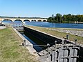
.JPG) Footbridge over the canal in Lalinde |
|
| Water code | FR : P --- 0082 |
| location | France , Nouvelle-Aquitaine region |
| length | 15.5 km |
| Built | 1838-1844 |
| class | <I. |
| Beginning | Mauzac , municipality of Mauzac-et-Grand-Castang |
| The End | Tuilières , municipality of Mouleydier |
| Descent structures | 5 |
| Ports | Lalinde, Port de Couze, Saint-Capraise-de-Lalinde |
| Used river | Dordogne |
| Kilometrage | from Mauzac to Tuilières |
| Most of the canal is closed to shipping! | |
The Canal de Lalinde is a former French shipping canal in the Dordogne in the region Nouvelle-Aquitaine . It is a right side channel of the Dordogne River with a length of 15.5 kilometers.
Course of the canal
The canal branches off at the village of Mauzac in the municipality of Mauzac-et-Grand-Castang on the right side of the river from the Dordogne and runs parallel to the river at a distance of 50 to a maximum of 400 meters until its re- confluence at Tuilières in the municipality of Mouleydier . On his way he passes the places Lalinde , with the two docks in Lalinde itself and in Port Couze , as well as Saint-Capraise-de-Lalinde .
- Starting point: 44 ° 51 ′ 47 ″ N , 0 ° 47 ′ 59 ″ E
- End point: 44 ° 50 ′ 49 ″ N , 0 ° 37 ′ 48 ″ E
technical infrastructure
The canal has a total length of 15.5 kilometers and has nine locks , six of which are arranged at the lower end of the canal in the form of a lock staircase. The lock chambers have a size of 29 × 6 meters and overcome a total difference in height of 21.4 meters.
history
The canal was designed to bypass narrow rivers and rapids on the Dordogne, which hindered navigation with the gabarre boats that are common here . The canal was built between 1838 and 1844. After its commissioning, the Canal de Lalinde served to ensure transport connections in the Dordogne Valley. With the advent of rail competition, however, the canal soon reached the limits of its economic performance. In 1926 the state removed it from the list of navigable waters in France, but continued to use it until 1945.
The entire structure has been registered as a Monument historique since 1996 .
Recovery plans
Efforts are now being made to make this canal navigable again for tourism. Since 2014, the four-kilometer section from Saint-Capraise-de-Lalinde to Port Couze can again be used with tourist gabarres.
Mauzac lock

Lalinde lock and harbor basin

Borie-Basse lock

Saint-Capraise-de-Lalinde harbor basin

Canal bridge in Saint-Capraise-de-Lalinde

Tuilères lock staircase

.JPG)


Web links
- Overview of the entire building with pictures
- History of the Canal (French)
- Information about the channel in the Babel project (French)
Individual evidence
- ↑ Water information system Service d'Administration National des Données et Référentiels sur l'Eau (French) ( information ), accessed on February 4, 2015
- ↑ Entry no. PA24000005 in the Base Mérimée of the French Ministry of Culture (French)