
Bayac
|
Bayac Baiac |
||
|---|---|---|
|
||
| region | Nouvelle-Aquitaine | |
| Department | Dordogne | |
| Arrondissement | Bergerac | |
| Canton | Lalinde | |
| Community association | Communes des Bastides Dordogne-Périgord | |
| Coordinates | 44 ° 48 ' N , 0 ° 44' E | |
| height | 42-173 m | |
| surface | 10.23 km 2 | |
| Residents | 351 (January 1, 2017) | |
| Population density | 34 inhabitants / km 2 | |
| Post Code | 24150 | |
| INSEE code | 24027 | |
| Website | www.bayac.fr | |
 Bayac Town Hall |
||

Bayac is a French municipality with 351 inhabitants (at January 1, 2017) in the department of Dordogne in the region Nouvelle-Aquitaine (before 2016: Aquitaine ). The municipality belongs to the Arrondissement of Bergerac and the canton of Lalinde (until 2015: canton of Beaumont-du-Périgord ).
The name in the Occitan language is Baiac and goes back to a country estate in Gallo-Roman times that belonged to a certain "Baius" or "Badius".
The inhabitants are called Bayacois and Bayacoises .
geography
Bayac is located about 20 km east of Bergerac in the Bergeracois region of the historic Périgord province .
Bayac is surrounded by the neighboring communities:
| Couze-et-Saint-Front | Pontours | |
| Lanquais |
.svg)
|
Bourniquel |
| Monsac | Beaumontois en Périgord |
Bayac is located in the catchment area of the Dordogne river . The Couze , one of its left tributaries, crosses the territory of the municipality.

The municipality received the “Three Stars” award given by the Association nationale pour la protection du ciel et de l'environnement nocturnes (ANPCEN) to municipalities that implement measures against light pollution .
history
Toponymy
The community was mentioned in the archives in 1479 in the form of Hospitium de Bayaco .
Population development
After records began, the population rose in the second half of the 19th century to a peak of around 715. In the following period, the size of the community fell to 310 inhabitants with short recovery phases up to the 1920s. A moderate growth phase began, which increased the size of the community to a relative high of around 400 inhabitants in the 1960s. This was followed by a further phase of population decline up to the 1980s to around 305 inhabitants before a slight growth set in, which has recently stagnated again.
| year | 1962 | 1968 | 1975 | 1982 | 1990 | 1999 | 2006 | 2010 | 2017 |
|---|---|---|---|---|---|---|---|---|---|
| Residents | 401 | 348 | 308 | 304 | 328 | 326 | 367 | 357 | 351 |

Attractions
Bayac Castle
.JPG)
The former hiding place was under the Castellanei von Couze and was probably built in the 15th century, because it was mentioned in 1479 under the name Hospitium de Bayaco . During the Huguenot Wars, Protestant troops led by Chaus de Monsac besieged the castle in 1580 and killed Seigneur Pierre de Bosredon. At the end of the 18th century it was owned by Charles Joseph de Losse. Extensive restoration work benefited the complex in the 19th century. In 1957 the castle belonged to the city of Paris and then to the Association pour la Gestion du Personnel des Administrations Parisiennes (Agospap) , which ran it as a holiday camp. In 2009 the property was returned to the city of Paris, which sold it to the Bayac municipality. The oldest part of the complex is a thick, round tower with a conical roof and a battlement on a protruding bay window supported by consoles . One of the windows was a dormer window in the style of Renaissance designed with capitals and shallow pilasters , decorated with diamonds. A triangular gable and side stone columns adorn its roof. The living area in the attic dates from the 18th century. Another square tower with battlements and mouths for field snakes is attached to the round tower. A square donjon with a stair tower conceals a stairwell with groin vaults . The facade of the castle and the roof of the round tower have been inscribed as a monument historique since November 5, 1970 .

Saint-Pierre-ès-Liens parish church
The church dedicated to St. Peter in Chains was built in 1839. The original church from the 12th century and the cemetery were approx. 200 m southeast of the castle. The Comte Charles Antoine de Losse, owner of the castle and mayor of the municipality, bought the church and the cemetery on July 27, 1839. In the same year he had the current church built in the classical style, tore down the old church and converted the cemetery into an agricultural area around. The year "1839" is engraved above the entrance on the west facade of today's church. The bell tower of manufactured stone is broken in its semi-circular gable by two circular arches. The church has a floor plan in the form of a Latin cross , the nave has only one nave.
La Gravette archaeological site
The La Gravette archaeological site is located in the municipality , where numerous flint tools have been discovered. Pastor Chastaing found the location in 1880. Excavations were carried out over several periods of time which revealed an almost industrial production of tools. These are in particular narrow, tapered blades with steep back retouching , which are characteristic of the late Aurignacia. The epoch (35,000–24,000 years ago) is later named as an independent culture after the name of the site, Gravettien , the typical blade with a gravette tip . Pastor Chastaing has brought together hundreds of remarkable artifacts and given them to the Vatican Museums . The site has been classified as a Monument historique since March 15, 1945 .
- La Gravette archaeological site

Site
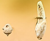
Jewelry made from bone material
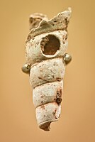
Jewelry made from seashells

Gravette tips from Gavaudun ( Lot-et-Garonne )


.jpg)
Mill and furnace du Colombier
The building was originally a wheat mill with two mill wheels, then a paper mill , before being converted into a foundry between 1850 and 1875 , while construction of a blast furnace on the same site began as early as 1840.
Economy and Infrastructure

Agriculture and tourism are the main economic drivers of the municipality.
Bayac is located in the AOC zones of the Noix du Périgord , the walnuts of the Périgord, and the nut oil of the Périgord.

total = 32
education
The municipality has a public pre-school and elementary school with 37 students in the 2018/2019 school year.
sport and freetime
- The Rocher du Corbeau in the southern part of the municipality is ideal for climbing . It offers 25 routes, often overhanging, with differences in height between 15 m and 20 m with ratings 5a to 7b on the French difficulty scale .
- Bayzac is located on the GR du Pays de Beaumonttois , a section on the pilgrimage route from Bordeaux to Rocamadour .
traffic
The Route départementale 660, the former Route nationale 660 , connects with Bayac Bergerac . The community can also be reached via Route départementale 27.
Web links
- Bayac on the association's website (French)
- Information on Périgord walnuts and Périgord nut oil (French)
Individual evidence
- ↑ Le nom occitan des communes du Périgord ( fr ) Départementrat des Dordogne. Retrieved October 1, 2018.
- ↑ Dordogne ( fr ) habitants.fr. Retrieved October 1, 2018.
- ↑ Ma commune: Bayac ( fr ) Système d'Information sur l'Eau du Bassin Adour Garonne. Retrieved October 1, 2018.
- ↑ Villes et Villages Étoilés - 3 étoiles ( fr ) Municipality of Bayac. Retrieved October 1, 2018.
- ^ Paul Vicomte de Gourgues: Dictionnaire topographique du département de la Dordogne ( fr ) In: Dictionnaire topographique de la France . Imprimerie nationale. P. 15. 1873. Retrieved October 1, 2018.
- ^ Notice Communale Bayac ( fr ) EHESS . Retrieved October 1, 2018.
- ↑ Populations légales 2015 Commune de Bayac (24027) ( fr ) INSEE . Retrieved October 1, 2018.
- ^ Château de Bayac ( fr ) Ministry of Culture and Communication . September 24, 2011. Accessed October 1, 2018.
- ^ Château ( fr ) Ministry of Culture and Communication . September 22, 2015. Accessed October 1, 2018.
- ↑ a b c d Sites historiques ( fr ) Bayac municipality. Retrieved October 1, 2018.
- ↑ Bayac ne veut pas d'un château abandonné ( fr ) Sud Ouest . September 1, 2010. Accessed October 1, 2018.
- ↑ église paroissiale Saint-Pierre-ès-Liens. ( fr ) Ministry of Culture and Communication . July 8, 1999. Retrieved October 1, 2018.
- ↑ Gisement de la Gravette ( fr ) Ministry of Culture and Communication . September 22, 2015. Accessed October 1, 2018.
- ↑ Bayac ( fr ) Conseil régional d'Aquitaine. Archived from the original on September 9, 2016. Retrieved October 1, 2018.
- ↑ Institut national de l'origine et de la qualité: Rechercher un produit ( fr ) Institut national de l'origine et de la qualité . Retrieved October 30, 2018.
- ↑ Caractéristiques des établissements en 2015 de Bayac (24027) ( fr ) INSEE . Retrieved October 1, 2018.
- ^ École maternelle et élémentaire ( fr ) National Ministry of Education. Retrieved October 1, 2018.
- ↑ Escalade à Bayac ( fr ) Bayac municipality. Retrieved October 1, 2018.
- ↑ Les chemins de Marie ( fr ) Retrieved October 1, 2018.