
Gavaudun
| Gavaudun | ||
|---|---|---|
|
||
| region | Nouvelle-Aquitaine | |
| Department | Lot-et-Garonne | |
| Arrondissement | Villeneuve-sur-Lot | |
| Canton | Le Haut Agenais Périgord | |
| Community association | Communes des Bastides en Haut Agenais Périgord | |
| Coordinates | 44 ° 34 ' N , 0 ° 53' E | |
| height | 105-243 m | |
| surface | 21.33 km 2 | |
| Residents | 284 (January 1, 2017) | |
| Population density | 13 inhabitants / km 2 | |
| Post Code | 47150 | |
| INSEE code | 47109 | |
 View of the center of Gavaudun |
||

Gavaudun is a French municipality with 284 inhabitants (at January 1, 2017) in the department of Lot-et-Garonne in the region Nouvelle-Aquitaine (before 2016: Aquitaine ). The municipality belongs to the arrondissement of Villeneuve-sur-Lot and the canton of Le Haut Agenais Périgord (until 2015: canton of Monflanquin ).
The name of the community is derived from the Gabalier , a Celtic tribe that was originally native to Gévaudan .
The inhabitants are called Gavaudunois and Gavaudunoises .
geography
Gavaudun is located about 25 km northeast of Villeneuve-sur-Lot in the historic province of Agenais on the northern border with the neighboring Dordogne department .
Gavaudun is surrounded by the eight neighboring communities:
|
Vergt-de-Biron (Dordogne) |
Biron (Dordogne) Lacapelle-Biron |
Blanquefort-sur-Briolance |
|
Paulhiac Montagnac-sur-Lède |
.svg)
|
Cuzorn |
| Salles |
Gavaudun is located in the catchment area of the Garonne River .
The Lède , a tributary of the Lot , crosses the area of the municipality together with its tributary, the Ruisseau de Clairfond.
Two tributaries of the Lémance , the Ruisseau de Lasbozios and the Ruisseau du Vignal, have their source in Gavaudun.
The drainless Ruisseau de Beldina also irrigates the municipality.

history
The rock face opposite Gavaudun Castle and near the Lède has been inhabited since prehistory . During excavations in the grotto Le Milieu, human remains from the periods of the Moustérien and Aurignacien were discovered.
The Lède had a major impact on the local economy from an early age. Eight watermills were once in operation over a distance of six kilometers . On the heights of the limestone mountains there are sediments with iron-containing minerals that chestnut trees carry. The ore smelting with the help of charcoal was probably carried out before the beginning of our era, as evidenced by traces in the form of slag . From around the 15th century, processing moved to the river valley to benefit from hydropower. In the 17th century, three mills were converted into paper mills . Some of the paper was exported to the Netherlands . These two economic activities were given up in the middle of the 19th century. A wool spinning mill was in operation until 1988.
- Prehistoric artifacts from sites in Gavaudun

Arrowheads from the Gravettia

Microliths from the Aurignacia

Scratches from the Aurignacia
.jpg)
.jpg)

Population development
After records began, the population rose to a peak of around 1,090 by the middle of the 19th century. In the period that followed, the size of the community fell to around 255 inhabitants during short recovery phases until the 1970s, before the size stabilized at a level of around 290 inhabitants, which has recently stagnated again.
| year | 1962 | 1968 | 1975 | 1982 | 1990 | 1999 | 2006 | 2011 | 2017 |
|---|---|---|---|---|---|---|---|---|---|
| Residents | 320 | 276 | 256 | 269 | 287 | 316 | 286 | 299 | 284 |

Attractions
- Parish Church of Saint-Sardos in the hamlet Laurenque from the 12th century, when historique monument classified
- Ruins of the Saint-Sardos priory in the hamlet of Laurunque from the 15th / 16th centuries. Century, partly inscribed as Monument historique
- Ruins of the castle from the 13th century, when monument historique classified
- Lède valley, nature reserve since 1999
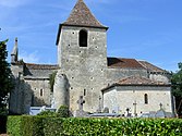
Parish Church of Saint-Sardos

Former priory

Castle ruins


Economy and Infrastructure
Trade and services are the main economic drivers of the community.

total = 49
education
The municipality has a public preschool and elementary school with 49 pupils in the 2018/2019 school year.
traffic
Gavaudun can be reached via routes départementales 150, 162, 235 and 255.
Web links
- Website of the Gavaudun Castle Ruins (French)
Individual evidence
- ↑ a b Gavaudun ( fr ) Conseil régional d'Aquitaine. Archived from the original on September 9, 2016. Retrieved February 10, 2019.
- ↑ Lot-et-Garonne ( fr ) habitants.fr. Retrieved February 10, 2019.
- ↑ Ma commune: Gavaudun ( fr ) Système d'Information sur l'Eau du Bassin Adour Garonne. Retrieved February 10, 2019.
- ↑ Notice Communale Gavaudun ( fr ) EHESS . Retrieved February 10, 2019.
- ↑ Populations légales 2016 Commune de Gavaudun (47109) ( fr ) INSEE . Retrieved February 10, 2019.
- ↑ Caractéristiques des établissements en 2015 Commune de Gavaudun (47109) ( fr ) INSEE . Retrieved February 10, 2019.
- ^ École maternelle et élémentaire ( fr ) National Ministry of Education. Retrieved February 8, 2019.