Bourlens
|
Bourlens Borlens |
||
|---|---|---|
|
|
||
| region | Nouvelle-Aquitaine | |
| Department | Lot-et-Garonne | |
| Arrondissement | Villeneuve-sur-Lot | |
| Canton | Le Fumélois | |
| Community association | Fumel Vallée du Lot | |
| Coordinates | 44 ° 25 ′ N , 0 ° 58 ′ E | |
| height | 96-235 m | |
| surface | 15.44 km 2 | |
| Residents | 380 (January 1, 2017) | |
| Population density | 25 inhabitants / km 2 | |
| Post Code | 47370 | |
| INSEE code | 47036 | |
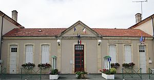
 Town Hall (Mairie) and Bourlens School |
||
Bourlens ( Occitan : Borlens ) is a municipality with 380 inhabitants (as of January 1 2017) in France in the department of Lot-et-Garonne in the region Nouvelle-Aquitaine (2016: Aquitaine ). Bourlens belongs to the arrondissement of Villeneuve-sur-Lot and the canton of Le Fumélois (until 2015: canton of Tournon-d'Agenais ).
geography
Bourlens is located about 21 kilometers east-northeast of Villeneuve-sur-Lot . Bourlens is surrounded by the neighboring communities of Montayral in the north, Thézac in the east, Tournon-d'Agenais in the south, Cazideroque in the south-west and Saint-Georges in the west and north-west.
Population development
| 1962 | 1968 | 1975 | 1982 | 1990 | 1999 | 2006 | 2013 |
|---|---|---|---|---|---|---|---|
| 338 | 308 | 342 | 368 | 376 | 354 | 369 | 357 |
| Source: Cassini and INSEE | |||||||
Attractions
- Saint-Pierre-aux-Liens church from the 11th century
Web links
Commons : Bourlens - collection of images, videos and audio files

