
Castillonnès
|
Castillonnès Castilhones |
||
|---|---|---|
.svg)
|
|
|
| region | Nouvelle-Aquitaine | |
| Department | Lot-et-Garonne | |
| Arrondissement | Villeneuve-sur-Lot | |
| Canton | Le Val du Dropt | |
| Community association | Bastides en Haut Agenais Périgord | |
| Coordinates | 44 ° 39 ′ N , 0 ° 36 ′ E | |
| height | 62-145 m | |
| surface | 19.4 km 2 | |
| Residents | 1,417 (January 1, 2017) | |
| Population density | 73 inhabitants / km 2 | |
| Post Code | 47330 | |
| INSEE code | 47057 | |
| Website | http://www.mairie-castillonnes.fr/ | |
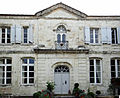
 Town hall (Hotel de ville) of Castillonnès |
||

Castillonnès ( Occitan : Castilhones ) is a commune with 1,417 inhabitants (as of January 1 2017) in the department of Lot-et-Garonne in the region Nouvelle-Aquitaine . It belongs to the arrondissement of Villeneuve-sur-Lot and the canton of Le Val du Dropt (until 2015: canton of Castillonnès ). The inhabitants are called Castillonnésiens .
geography
Castillonnès is about 24 kilometers south-southeast of Bergerac . The Dropt limits the community in the north. Castillonnès is surrounded by the neighboring communities of Saint-Quentin-du-Dropt in the north, Ferrensac in the east, Lougratte in the south, Montauriol in the west and south-west, Douzains in the west and Cahuzac in the north-west.
The National Route 21 runs through the municipality .
history
A bastide was founded around 1259 by Alfonso von Poitiers .
Population development
| 1962 | 1968 | 1975 | 1982 | 1990 | 1999 | 2006 | 2013 |
|---|---|---|---|---|---|---|---|
| 1,524 | 1,408 | 1,353 | 1,382 | 1,424 | 1,325 | 1,499 | 1,414 |
| Source: Cassini and INSEE | |||||||
Attractions
- Saint-Pierre church
- Hôtel Cours de Thomazeau, built around 1770, monument historique since 1996
- Market hall from 1905
- hippodrome

Saint-Pierre church
Hotel Cours de Thomazeau

Market hall


