Laussou
| Laussou | ||
|---|---|---|
|
|
||
| region | Nouvelle-Aquitaine | |
| Department | Lot-et-Garonne | |
| Arrondissement | Villeneuve-sur-Lot | |
| Canton | Le Haut Agenais Périgord | |
| Community association | Bastides en Haut Agenais Périgord | |
| Coordinates | 44 ° 35 ' N , 0 ° 47' E | |
| height | 75-200 m | |
| surface | 17.15 km 2 | |
| Residents | 295 (January 1, 2017) | |
| Population density | 17 inhabitants / km 2 | |
| Post Code | 47150 | |
| INSEE code | 47141 | |
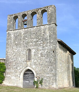
 Parish Church of Saint-Pierre |
||
Laussou is a French commune of 295 inhabitants (at January 1, 2017) in the department of Lot-et-Garonne in the region Nouvelle-Aquitaine (before 2016: Aquitaine ). The municipality belongs to the arrondissement of Villeneuve-sur-Lot and the canton of Le Haut Agenais Périgord (until 2015: canton of Monflanquin ).
The name of the municipality is derived from the river of the same name, which forms the natural border with the eastern and southern neighboring communities.
geography
Laussou is located about 20 kilometers northeast of Villeneuve-sur-Lot in the historic province of Agenais on the northern edge of the department.
Laussou is surrounded by the five neighboring communities:
| Saint-Etienne-de-Villeréal | Dévillac | |
| Saint-Eutrope-de-Born |

|
Paulhiac |
| Monflanquin |
Laussou is located in the catchment area of the Garonne River .
The Lède , a tributary of the Lot , crosses the territory of the commune along with its tributaries,
- the Ruisseau de Favier and
- the Laussou with its tributary,
- the Ruisseau de Lasgrèses, and its tributaries that arise in Laussou,
- the Ruisseau de Basset,
- the Ruisseau Maline and
- the Ruisseau Biard.
history
The geographical location on several rivers allows an early settlement. However, the oldest archaeological finds in the municipality date from the High Middle Ages . A priory with a church in the hamlet of Envals was mentioned in the 12th century . This happened in a turbulent time on the border of the Agenais and Périgord, a focal point of the conflicts of the Hundred Years War .
Population development
When the records began, the population peaked at around 830. In the following period, the size of the community fell to around 210 inhabitants with brief recovery phases up to the 1980s, before a phase of moderate growth began, which continues today.
| year | 1962 | 1968 | 1975 | 1982 | 1990 | 1999 | 2006 | 2011 | 2017 |
|---|---|---|---|---|---|---|---|---|---|
| Residents | 312 | 266 | 263 | 208 | 255 | 234 | 252 | 273 | 295 |
Attractions
Parish Church of Saint-Pierre
The church dedicated to the Apostle Peter was built in the 12th century. Your nave was partially rebuilt in the 13th century. The bell gable was reworked during the Gothic period . The inner walls of the choir and part of the nave are decorated with blind arcades . A wall painting using glue paint was created in the 16th century and beautifies all walls. Only the colors yellow ocher and red ocher have been used. During the 1950s the roof of the church collapsed. The ground and underground of the former cemetery that surrounds the church has been inscribed as a Monument historique since September 15, 1994 , the church has been classified as a Monument historique since September 20, 2006 .
Barayre Castle
It was built in the 15th century in the hamlet of Envals with thick stone walls and oak parquet that is still there today . 20 hectares of meadow surrounds the property, which is now privately owned and not accessible to the public.
Boinet Castle
At the beginning of the 17th century, Jean Sarrau, the first consul of Monflanquin, became the owner of Boinet Castle in the hamlet of the same name. He has since held the title Sieur de Boinet de Gibel . In 1610 he was knighted for his services to the French state. His grandson Claude Sarrau de Boinet was born at the castle in 1603. He is the most famous of the family. From 1627 to 1636 he was adviser to the Parliament of Normandy , then adviser to the French king until 1640. He then returned to Normandy. His grandchildren followed his path and helped found the Académie nationale des sciences, belles-lettres et arts de Bordeaux in 1712. The Sarrau family kept the castle until the French Revolution . It is now privately owned and not open to the public.
Economy and Infrastructure
Agriculture with its focus on the cultivation of mixed crops and fruit growing is still one of the most important economic factors in the municipality.

Total = 31
traffic
Laussou can be reached via Routes départementales 272 and 667, the former Route nationale 667 .
Web links
Individual evidence
- ↑ a b c d Laussou ( fr ) Conseil régional d'Aquitaine. Archived from the original on December 25, 2014. Retrieved March 14, 2019.
- ↑ Ma commune: Laussou ( fr ) Système d'Information sur l'Eau du Bassin Adour Garonne. Retrieved March 14, 2019.
- ↑ Notice Communale Laussou ( fr ) EHESS . Retrieved March 14, 2019.
- ↑ Populations légales 2016 Commune de Laussou (47141) ( fr ) INSEE . Retrieved March 14, 2019.
- ^ Eglise Saint-Pierre ( fr ) French Ministry of Culture . November 30, 2015. Accessed March 14, 2019.
- ↑ Château de Barayre ( fr ) chateau-fort-manoir-chateau.eu. Retrieved March 14, 2019.
- ↑ Château de Boinet ( fr ) chateau-fort-manoir-chateau.eu. Retrieved March 14, 2019.
- ↑ Caractéristiques des établissements en 2015 Commune de Laussou (47141) ( fr ) INSEE . Retrieved March 14, 2019.


