
Cuzorn
|
Cuzorn Cusòrn |
||
|---|---|---|
|
||
| region | Nouvelle-Aquitaine | |
| Department | Lot-et-Garonne | |
| Arrondissement | Villeneuve-sur-Lot | |
| Canton | Le Fumélois | |
| Community association | Fumel Vallée du Lot | |
| Coordinates | 44 ° 33 ' N , 0 ° 57' E | |
| height | 76-242 m | |
| surface | 23.34 km 2 | |
| Residents | 849 (January 1, 2017) | |
| Population density | 36 inhabitants / km 2 | |
| Post Code | 47500 | |
| INSEE code | 47077 | |
 Mairie Cuzorn |
||

Cuzorn ( Occitan Cusòrn ) is a French municipality with 849 inhabitants (at January 1, 2017) in the department of Lot-et-Garonne in the region Nouvelle-Aquitaine (2015 Aquitaine ). It belongs to the Arrondissement of Villeneuve-sur-Lot and the Fumel Vallée du Lot municipal association, which was founded in 2016 . The inhabitants are called Cuzornais .
geography
The municipality of Cuzorn is located in the natural region of the Bouriane in the narrow, deeply cut valley of the Lémance , a tributary of the Lot , about 33 kilometers northeast of Villeneuve-sur-Lot and 55 kilometers southeast of Bergerac . The community area of 23.34 km² is characterized by chestnut forests on the high plateaus as well as fields, pastures and orchards.
The villages of Lascombes, Ratier, Mélis, Lajasse Mélis, Lagarde, Laborde, Coustélou, Al Calfour, Péméja (partially), Laborderie, Capoulette, Gibert, Bret, La Forge, Pourquiès (partially), Le Vignal, Belarbre, Guiraudel belong to Cuzorn , Tesquet, La Jasse Tesquet and Vignasse as well as other hamlets and individual farms.
Neighboring municipalities of Cuzorn are Saint-Front-sur-Lémance in the north and northeast, Fumel in the east and southeast, Monsempron-Libos in the south, Salles in the southwest, Gavaudun in the west and Blanquefort-sur-Briolance in the northwest.
history
The Château Cuzorn was built in the 13th century on the limestone cliffs above the Lémance to control the Lémance Valley. The ruins still bear witness to its former importance in the Hundred Years' War, the Wars of Religion and the French Revolution. The church of Saint-Martin also dates from the 13th century and was built high above the river valley. Iron used to be mined in the area around Cuzorn, which made forges and mills possible. The last watermill still preserved today is the Moulin de Pombié
Population development
| year | 1962 | 1968 | 1975 | 1982 | 1990 | 1999 | 2006 | 2016 | |
| Residents | 823 | 822 | 786 | 837 | 901 | 870 | 834 | 850 | |
| Source: Cassini and INSEE | |||||||||
Attractions
- Parish church of Saint-Martin in the Gibert district with Romanesque choir, former priory of the abbeys of Saint-Geraud in Aurillac , Saint-Front and Monsempron , Monument historique
- Remains of the Château Cuzorn, first mentioned as Cuzorn castrum in 1271, belonging to the Bailliage Tournon , Monument historique
- Roudigou mansion from the 18th century with a square pigeon tower
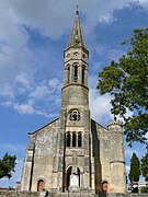
Saint Martin Church

Romanesque choir of the church
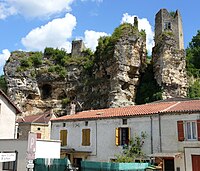
Remains of the Château Cuzorn


Economy and Infrastructure
There are several craft and service companies in Cuzorn. In addition, 30 farms are located in Cuzorn (cereal and vegetable cultivation, orchards, dairy farming, horse breeding, a winery).
Cuzorn is on the Route nationale 710 from Siorac-en-Périgord to Fumel . Near the city of Cahors , 50 kilometers to the east, there is a connection to the A 20 autoroute from Vierzon to Toulouse . The eight-kilometer distant station of Monsempron-Libos is located on the railway line from Niversac to Agen .
Personalities
- Hilarion Ballande (1820–1887), actor, playwright and theater director
supporting documents
- ↑ short history on fumelvalleedulot.com (French)
- ↑ Cuzorn on cassini.ehess.fr
- ↑ Cuzorn on insee.fr
- ^ Entry in the Base Mérimée of the Ministry of Culture. Retrieved January 22, 2019 (French).
- ^ Entry in the Base Mérimée of the Ministry of Culture. Retrieved January 22, 2019 (French).
- ↑ Farms on annuaire-mairie.fr (French)