
Sainte-Colombe-de-Villeneuve
| Sainte-Colombe-de-Villeneuve | ||
|---|---|---|
|
||
| region | Nouvelle-Aquitaine | |
| Department | Lot-et-Garonne | |
| Arrondissement | Villeneuve-sur-Lot | |
| Canton | Villeneuve-sur-Lot-2 | |
| Community association | Grand Villeneuvois | |
| Coordinates | 44 ° 22 ′ N , 0 ° 40 ′ E | |
| height | 70-224 m | |
| surface | 18.92 km 2 | |
| Residents | 492 (January 1, 2017) | |
| Population density | 26 inhabitants / km 2 | |
| Post Code | 47300 | |
| INSEE code | 47237 | |

Sainte-Colombe-de-Villeneuve is a French municipality with 492 inhabitants (as of January 1 2017) in the department of Lot-et-Garonne in the region Nouvelle-Aquitaine . It belongs to the Arrondissement of Villeneuve-sur-Lot and the Canton of Villeneuve-sur-Lot-2 (until 2015: Canton of Villeneuve-sur-Lot-Sud ).
geography
Sainte-Colombe-de-Villeneuve is located about five kilometers southwest of Villeneuve-sur-Lot . Sainte-Colombe-de-Villeneuve is surrounded by the neighboring communities of Bias in the north, Pujols in the east, Saint-Antoine-de-Ficalba in the south-east, Castella in the south and south-east, Sembas in the south, Dolayrac in the west and south-west and Allez-et- Cazeneuve to the west and northwest.
Population development
| year | 1962 | 1968 | 1975 | 1982 | 1990 | 1999 | 2006 | 2013 |
| Residents | 387 | 337 | 279 | 326 | 330 | 364 | 403 | 488 |
| Source: Cassini and INSEE | ||||||||
Attractions
- Sainte-Colombe Church
- Sainte-Madeleine church in Laurier, monument historique since 1926
- Lastournelle cave
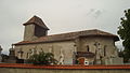
Sainte-Colombe Church
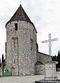
Sainte-Madeleine church

Statue near Lastournelle


