
Cancon
| Cancon | ||
|---|---|---|
.svg)
|
|
|
| region | Nouvelle-Aquitaine | |
| Department | Lot-et-Garonne | |
| Arrondissement | Villeneuve-sur-Lot | |
| Canton | Le Haut Agenais Périgord | |
| Community association | Bastides en Haut Agenais Périgord | |
| Coordinates | 44 ° 32 ' N , 0 ° 38' E | |
| height | 90-217 m | |
| surface | 24.49 km 2 | |
| Residents | 1,340 (January 1, 2017) | |
| Population density | 55 inhabitants / km 2 | |
| Post Code | 47290 | |
| INSEE code | 47048 | |
| Website | http://www.cancon.fr/ | |
 City Hall (Mairie) of Cancon |
||

Cancon is a municipality with 1340 inhabitants (as of January 1 2017) in France in the department of Lot-et-Garonne in the region Nouvelle-Aquitaine . It belongs to the arrondissement of Villeneuve-sur-Lot and the canton of Le Haut Agenais Périgord (until 2015: canton of Cancon ). The inhabitants are called Canconnais .
geography
Cancon is about 16 kilometers north-northwest of Villeneuve-sur-Lot . Cancon is surrounded by the neighboring communities Lougratte in the north, Saint-Eutrope-de-Born in the northeast, Boudy-de-Beauregard in the east, Beaugas in the south, Moulinet in the west and Saint-Maurice-de-Lestapel in the northwest.
The National Route 21 runs through the municipality .
Population development
| 1962 | 1968 | 1975 | 1982 | 1990 | 1999 | 2006 | 2013 |
|---|---|---|---|---|---|---|---|
| 1,227 | 1,305 | 1,602 | 1,334 | 1,324 | 1,287 | 1,283 | 1,329 |
| Source: Cassini and INSEE | |||||||
Attractions
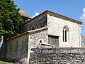
- Saint-Martial church, built in 1905 after it was discovered that the old Saint-Martial church was on an unstable ground
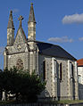
- Notre-Dame church in Milhac, Gothic church building from the 15th / 16th centuries Century, Monument historique
- hospice

Saint-Martial church
Notre-Dame church
Chapel of the hospice


Personalities
- Fernand Pouillon (1912–1986), architect
Web links
Commons : Cancon - collection of pictures, videos and audio files