Le Temple-sur-Lot
|
Le Temple-sur-Lot Lo Temple d'Òlt |
||
|---|---|---|

|
|
|
| region | Nouvelle-Aquitaine | |
| Department | Lot-et-Garonne | |
| Arrondissement | Villeneuve-sur-Lot | |
| Canton | Le Livradais | |
| Community association | Lot and Tolzac | |
| Coordinates | 44 ° 23 ' N , 0 ° 32' E | |
| height | 32-190 m | |
| surface | 16.91 km 2 | |
| Residents | 1,027 (January 1, 2017) | |
| Population density | 61 inhabitants / km 2 | |
| Post Code | 47110 | |
| INSEE code | 47306 | |
| Website | http://www.letemplesurlot.fr/ | |
Le Temple-sur-Lot ( Occitan : Lo Temple d'Olt ) is a French town with 1,027 inhabitants (at January 1, 2017) in the department of Lot-et-Garonne in the region Nouvelle-Aquitaine (before 2016 Aquitaine ). The municipality is located in the arrondissement of Villeneuve-sur-Lot and is part of the canton of Le Livradais (until 2015 Sainte-Livrade-sur-Lot ).
geography
Le Temple-sur-Lot is located about 19 kilometers north-north-west of Agen am Lot , which borders the municipality in the north. Le Temple-sur-Lot is surrounded by the neighboring communities of Castelmoron-sur-Lot in the north and north-west, Fongrave in the north, Sainte-Livrade-sur-Lot in the east, Dolmayrac in the east and south-east, Montpezat in the south and Granges-sur-Lot in the West.
Population development
| 1962 | 1968 | 1975 | 1982 | 1990 | 1999 | 2006 | 2017 |
|---|---|---|---|---|---|---|---|
| 1,080 | 1,081 | 970 | 977 | 979 | 862 | 991 | 1027 |
| Sources: Cassini and INSEE | |||||||
Attractions
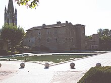
- Notre-Dame church
- Templar command from the 13th century

