Casseneuil
| Casseneuil | ||
|---|---|---|

|
|
|
| region | Nouvelle-Aquitaine | |
| Department | Lot-et-Garonne | |
| Arrondissement | Villeneuve-sur-Lot | |
| Canton | Le Livradais | |
| Community association | Grand Villeneuvois | |
| Coordinates | 44 ° 27 ' N , 0 ° 37' E | |
| height | 38-204 m | |
| surface | 18.09 km 2 | |
| Residents | 2,386 (January 1, 2017) | |
| Population density | 132 inhabitants / km 2 | |
| Post Code | 47440 | |
| INSEE code | 47049 | |
| Website | www.mairie-de-casseneuil.com | |
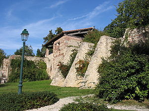
 Casseneuil, city fortifications |
||
Casseneuil is a municipality with 2386 inhabitants (at January 1, 2017) in France in the department of Lot-et-Garonne in the region Nouvelle-Aquitaine .
geography
Casseneuil is located on a natural peninsula at the confluence of the right tributary Lède into the Lot . Immediately before this confluence, the Sône also flows into the Lède, which further strengthens the city's water-based location.
history
- The origins of the city date back to Gallo-Roman times . At that time it was known under the name Cassinogilum , which means something like "clearing in the oak forest".
- Due to its strategic position, it was heavily fortified in the Middle Ages .
- During the Albigensian Crusades against the Cathars , the city was besieged and captured in 1209 . Here the first pyre of the war was lit and many heretics were burned. During the summer of 1214 , the city was besieged again by Simon IV. De Montfort , conquered and most of the inhabitants killed.
- On April 12, 1229, the Count of Toulouse, committed Raimund VII. In the Treaty of Meaux-Paris Casseneuil among other things, to destroy the walls of 30 fortifications, among them.
Attractions
- Church of St. Peter and Paul from the 13th century, rebuilt several times
- Remains of the city fortifications on the banks of the Lède
Web links
Commons : Casseneuil - collection of images, videos and audio files
- Official website of the city (French)
