
Monflanquin
| Monflanquin | ||
|---|---|---|
.svg)
|
|
|
| region | Nouvelle-Aquitaine | |
| Department | Lot-et-Garonne | |
| Arrondissement | Villeneuve-sur-Lot | |
| Canton | Le Haut Agenais Périgord (main town) | |
| Community association | Bastides en Haut Agenais Périgord | |
| Coordinates | 44 ° 32 ' N , 0 ° 46' E | |
| height | 64-207 m | |
| surface | 62.21 km 2 | |
| Residents | 2,313 (January 1, 2017) | |
| Population density | 37 inhabitants / km 2 | |
| Post Code | 47150 | |
| INSEE code | 47175 | |

Monflanquin is a French commune with 2,313 inhabitants (at January 1, 2017) in the department of Lot-et-Garonne in the region Nouvelle-Aquitaine . It belongs to the arrondissement of Villeneuve-sur-Lot and the canton of Le Haut Agenais Périgord .
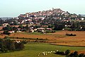
geography
Monflanquin is located on a hill above the Lède valley on the border of Périgord , Quercy and Guyenne . The place is one of the most beautiful villages in France .
Population development
| year | 1962 | 1968 | 1975 | 1982 | 1990 | 1999 | 2007 | 2017 |
| Residents | 2308 | 2354 | 2368 | 2356 | 2431 | 2258 | 2342 | 2313 |
Attractions
- Saint-André church (1250/90, Monument historique )
- Du Prince Noir House (14th century)
- Roquefère Castle
Monflanquin

Saint-André church

Prince Noir


Personalities
- Pierre Saint-Amant (1800–1872), chess player
Web links
Commons : Monflanquin - collection of images, videos and audio files