
Domme
| Domme | ||
|---|---|---|
.svg)
|
|
|
| region | Nouvelle-Aquitaine | |
| Department | Dordogne | |
| Arrondissement | Sarlat-la-Canéda | |
| Canton | Vallée Dordogne | |
| Community association | Domme Villefranche-du-Périgord | |
| Coordinates | 44 ° 48 ' N , 1 ° 13' E | |
| height | 60-303 m | |
| surface | 24.91 km 2 | |
| Residents | 911 (January 1, 2017) | |
| Population density | 37 inhabitants / km 2 | |
| Post Code | 24250 | |
| INSEE code | 24152 | |
| Website | http://www.domme.fr/ | |
 Domme in the morning mist |
||

Domme [ dɔm ] (of Occitan Doma ) is a French municipality with 911 inhabitants (at January 1, 2017) in the Dordogne in the region Nouvelle-Aquitaine . Built in the Middle Ages as a bastide on a 250 meter high rocky promontory above the Dordogne , it is now one of the most beautiful villages in France in the association Les plus beaux villages de France and is a major tourist attraction in the Périgord Noir region. Domme is also known as the "Acropolis of Périgord" .
Population development
| year | 1962 | 1968 | 1975 | 1982 | 1990 | 1999 | 2009 | 2017 |
| Residents | 855 | 876 | 891 | 910 | 1030 | 987 | 989 | 911 |
| Sources: Cassini and INSEE | ||||||||
Bastide

Bastide (from Occitan bastir ' to build' ) is the name for the towns and villages that were founded in the middle ages in an undeveloped landscape and built in one go, in contrast to localities that have “grown” over longer periods of time.
Reason for edification
The change in the rulership of southern and western France to the English crown through marital connections between the royal houses in 1152 had led to armed conflicts. The new borders, partly identical to the course of the Dordogne, required new military strategies. In addition to the occupation of opposing castles, around 400 fortified "artificial" settlements, the bastides, were built on both sides between 1229 and 1373, which were supposed to offer the population in the area protection from robberies and wars.
Choice of location
The rough structure of the medieval town of Domme differs from the typical Bastide town design, which provides for a consistently right-angled and checkerboard street alignment, as does the border in the form of a regular rectangle with a defensive wall, defensive towers and gates. Obviously, the exposed location on an elevation overlooking the landscape and the Dordogne valley was so important in the choice of location that the strict floor plan of the city plan was dispensed with.
particularities

Instead, you will find a trapezoidal city map in Domme with streets running polygonally to one another, due to irregular geographic height profiles. Even when the city wall was being built, there was hardly any straight line. Rather, the work on the fortifications, which only began in 1310, 27 years after the city was founded, indicates extreme difficulties with their construction.
Another special feature is the city's ground plan, which tapers almost to the west, which is presumably based on the location of the old castle fortress, to which a structural connection was sought.
Of disadvantageous importance in the fortification of the city turned out to be that on the side of the city facing north to the Dordogne valley, a fortress wall was dispensed with, as it was believed that the steep rock walls were insurmountable for attackers.
history
Beginnings

The history of the origins of the Bastide Domme is related to the Domme-Vieille castle fortress from the 11th and 12th centuries, which was previously located on the western edge of the plateau . The eastern side of the plateau was built on the initiative of King Philip III. des Kühnen acquired in 1281 by his Seneschal Simon de Melun , while the castle itself remained in the possession of the Bishop of Sarlat .
The Bastide Domme was founded in 1281 by Philip the Bold to control the Dordogne Valley more effectively. At the same time, possible expansion plans by English settlers in Gascony should be averted.
The royal French bastide Domme was endowed with numerous privileges, including the right to mint its own coins, the designation of its own consuls , the establishment of a public administration and local jurisdiction, and numerous tax exemptions.
From 1307 to 1318, 70 Knights of the Templar Order were held as prisoners in the Porte des Tours city gate .

In the Hundred Years War
Despite or precisely because of its strategically favorable location, the Bastide Domme was often the subject of Anglo- Gasecognic expansion efforts in Aquitaine during the Hundred Years War , in which Domme was often the scene of intense fighting. Since 1347, the city has changed hands several times between French and English. During the chaos of war, the Augustinians founded a priory in Domme in 1375 . In 1417 the city was captured by the English, who then occupied it for almost twenty years. During this time the royal castle fortress was irretrievably destroyed.
It was not until 1438 that the bastide became definitely French. According to population surveys by the local clergy, the number of parishioners in the Bastide fell from almost 1,000 to just under 100 during this long period as a result of the consequences of the war. Leaving the bastide was strictly forbidden by order of the Seneschal of Périgord under threat of expropriation.
Wars of religion

After the end of the Hundred Years War, the Bastide Domme, as a strictly Catholic community, vehemently opposed Huguenot influence in the run-up to the wars of religion , whose plundering hordes also roamed the Périgord. In 1588, after sixteen years of siege, the Protestant captain Geoffroy de Vivans finally managed to climb the steep slope on the river side on the north side of the Bastide in a surprise night coup with thirty companions, to open the city gates for his siege army and to penetrate the city unnoticed. The cliffs had been left unpaved, trusting in their natural defensive effect.
Geoffroy de Vivans holed up in the bastide and set up a garrison there for four years . He had the Augustinian priory and the church building burned down and introduced the Protestant faith.
The escalation of denominational disputes in the country and the growing success of Catholics, especially in Périgord, forced Geoffroy in 1592 to sell the bastide, which was in ruins, to Catholics in 1592 for a payment of 40,000 livres .

Modern times
After clearing up and extensive restoration of the Domme settlement, viticulture flourished again in the 17th century. The city's successful markets were soon known throughout the region.
The market hall also dates from this time . The destroyed church was also rebuilt at that time and received the current portal and bell tower in the 19th century.
Attractions
city wall
The medieval city wall (French: Remparts ) has been preserved in almost its entire length and is partially accessible through an inner wall tour, the promenade des remparts . The southern part of the city is still accessed today via three gates.
Porte del Bos

The ogival gate is now just a simple passage in the city wall to the west, but was once closed by a portcullis.
Porte de la Combe
The south-facing gate tower is equipped with an ogival gate passage with portcullis. The masonry of the building, which is rectangular in plan, still protrudes clearly above the arched crown of the gate. The city walls adjoining on both sides have larger loopholes right next to the gate tower.
Porte des Tours
The best preserved city gate, which is also Dommes' landmark, takes its name from the two flanking towers, rounded on the outside in a semicircular plan, raised flat on the city side, clad with massive bossed masonry . These watchtowers were built towards the end of the 13th century by order of Philip the Fair . Between 1307 and 1318, seventy knights of the dissolved Knights Templar were held captive in its basement . They left a lot of graffiti on the walls . The towers continued to be used as prisons for a long time. On the outside of the city wall that adjoins both sides, you can see the oriels of medieval latrines, in the manner of machicolations . Roof structures that were once covered with slate were placed on top of the bulky masonry stumps.
Place de la Halle

The 17th century market hall named after her stands on the square , with arcades on one long side made of massive round stone pillars. The exit to the grotto , a stalactite cave, is located under the arcades . The caves served as a refuge for the people of Domme during the Hundred Years' War and the Wars of Religion. Opposite the market hall is the 16th century Maison de Gouverneur . In the northern corner of the square is the building of the church, rebuilt in 1622, which was partially destroyed after the conquest of Dommes by the Huguenot Vivans. The portal and bell tower were not completed until 1837.

panorama
From the northern promenade at the height of the cliffs of Domme, the promenade des falaises , or the La Barre viewing terrace , you can see the Dordogne valley in the west to Beynac and in the east to the Cingle de Montfort . The promenade is a popular and popular vantage point because of its unique panorama, which changes depending on the time of day and season.

Rue des Consuls
About halfway along the street, the old town hall is housed in a building from the 13th century. The Seneschal's court was once located here . A dungeon , into which one can look through a grille in the floor, is a reminder of this.
Place de la Rode
The Place de la Rode served as a place of execution in the Middle Ages. The origin of the name ( ròda Occitan for wheel ) reveals that those condemned to death were executed by wheels here. The Maison du Batteur de Monnaie , the house of the mint, has Gothic windows on the square .
Grande Rue
The Grande Rue is lined with numerous shops selling local specialties of the Périgord Noir. The house on the corner of Rue Geoffroy-de-Vivans has finely crafted window crosses from the Renaissance.
Rue de l'Abbaye
In this street you can find the remains of a Gothic cloister .
Musée d'Art et Traditions Populaires
- Local history museum

museum

Corner of the house with a lantern

Renaissance window

Gable with cross
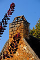
Gable with chimney
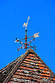
Weathercock


literature
- Susanne Böttcher (Ed.): Périgord, Dordogne, Limousin. (= The Green Guide. ) Travel-House-Media, Munich 2006, ISBN 3-8342-8995-7 .
- Thorsten Droste : Périgord and the Atlantic coast. Art and nature in the Dordogne valley and on the Côte d'Argent from Bordeaux to Biarritz (= DuMont documents: DuMont art travel guide. ). 9th edition. Dumont, Cologne 1989, ISBN 3-7701-1197-4 .