
Sainte-Orse
|
Sainte-Orse Senta Orsa |
||
|---|---|---|
|
||
| region | Nouvelle-Aquitaine | |
| Department | Dordogne | |
| Arrondissement | Sarlat-la-Canéda | |
| Canton | Haut-Périgord Noir | |
| Community association | Terrassonnais en Périgord Noir Thenon Hautefort | |
| Coordinates | 45 ° 12 ' N , 1 ° 5' E | |
| height | 163-292 m | |
| surface | 23.54 km 2 | |
| Residents | 358 (January 1, 2017) | |
| Population density | 15 inhabitants / km 2 | |
| Post Code | 24210 | |
| INSEE code | 24473 | |
 Town hall ( Mairie ) of Sainte-Orse |
||

Sainte-Orse ( Occitan : Senta Orsa ) is a French commune with 358 inhabitants (as of January 1, 2017) in the Dordogne department in Nouvelle-Aquitaine . It belongs to the arrondissement of Sarlat-la-Canéda and to the canton of Haut-Périgord Noir, which has existed since 2015 . The residents call themselves Saint-Orsais .
geography
Sainte-Orse is about 40 kilometers east of Périgueux. Sainte-Orse is surrounded by the neighboring communities of Tourtoirac in the north, Hautefort and Temple-Laguyon in the northeast, Granges-d'Ans in the east, Azerat in the south and southeast, Ajat in the south and southwest, Gabillou in the west and Chourgnac in the northwest.
Population development
| year | 1962 | 1968 | 1975 | 1982 | 1990 | 1999 | 2006 | 2013 |
|---|---|---|---|---|---|---|---|---|
| Residents | 527 | 486 | 460 | 404 | 372 | 358 | 366 | 380 |
| Source: Cassini and INSEE | ||||||||
Attractions
- Saint-Ours church from the 11th / 12th centuries Century, since 1970 Monument historique
- Sainte-Orse Castle from the 15th / 16th centuries century
- La Salle mansion from the 18th century
- La Faye mansion from the 18th century
- Laudonie Castle

Saint-Ours church
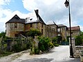
Sainte-Orse Castle

La Salle mansion

.JPG)
.JPG)
Personalities
- George de Peyrebrune (civil: Mathilde-Marie Georgina Élisabeth de Peyrebrune , 1841–1917), writer
Web links
Commons : Sainte-Orse - Collection of images, videos and audio files