
Saint-Vincent-le-Paluel
|
Saint-Vincent-le-Paluel Sent Vincenç de Paluèl |
||
|---|---|---|
|
||
| region | Nouvelle-Aquitaine | |
| Department | Dordogne | |
| Arrondissement | Sarlat-la-Canéda | |
| Canton | Sarlat-la-Canéda | |
| Community association | Sarlat-Black Perigord | |
| Coordinates | 44 ° 54 ′ N , 1 ° 17 ′ E | |
| height | 80-247 m | |
| surface | 6.86 km 2 | |
| Residents | 276 (January 1, 2017) | |
| Population density | 40 inhabitants / km 2 | |
| Post Code | 24200 | |
| INSEE code | 24512 | |
_Eglise_et_mairie.jpg) Town Hall (Mairie) and Church of Saint-Vincent-le-Paluel |
||

Saint-Vincent-le-Paluel ( Occitan : Sent Vincenç de Paluel ) is a French municipality with 276 inhabitants (as of January 1 2017), located in the department of Dordogne in the region Nouvelle-Aquitaine . The municipality is located in the arrondissement of Sarlat-la-Canéda and the canton of Sarlat-la-Canéda .
geography
Saint-Vincent-le-Paluel is located in the Périgord Noir landscape , about 60 kilometers south-east of Périgueux . Saint-Vincent-le-Paluel is surrounded by the neighboring communities of Sainte-Nathalène in the north, Prats-de-Carlux in the east, Calviac-en-Périgord in the southeast, Carsac-Aillac in the south and Sarlat-la-Canéda in the west.
Population development
| year | 1962 | 1968 | 1975 | 1982 | 1990 | 1999 | 2006 | 2013 |
| Residents | 123 | 114 | 109 | 121 | 151 | 207 | 246 | 269 |
| Source: Cassini and INSEE | ||||||||
Attractions
- Saint-Vincent church from the 12th century, monument historique since 1946
- Paluel Castle from the 15th century, monument historique since 1927
- 15th century Saint-Vincent mansion

Saint Vincent Church
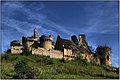
Paluel Castle

_-_03_Vue_Est-Sud-Est_Ch%C3%A2teau_du_Paluel.jpg)
Web links
Commons : Saint-Vincent-le-Paluel - Collection of images, videos and audio files