
Tourtoirac
|
Tourtoirac Tortoirac |
||
|---|---|---|
|
||
| region | Nouvelle-Aquitaine | |
| Department | Dordogne | |
| Arrondissement | Sarlat-la-Canéda | |
| Canton | Haut-Périgord Noir | |
| Community association | Terrassonnais en Périgord Noir Thenon Hautefort | |
| Coordinates | 45 ° 16 ' N , 1 ° 4' E | |
| height | 125-286 m | |
| surface | 25.43 km 2 | |
| Residents | 644 (January 1, 2017) | |
| Population density | 25 inhabitants / km 2 | |
| Post Code | 24390 | |
| INSEE code | 24555 | |
.JPG) View of Tourtoirac |
||

Tourtoirac ( Occitan : Tortoirac ) is a French municipality with 644 inhabitants (as of January 1 2017) in the north of the department Dordogne in the region Nouvelle-Aquitaine . The municipality is part of the canton of Haut-Périgord Noir (until 2015: canton of Hautefort ) in the arrondissement of Sarlat-la-Canéda . The inhabitants are called Tourtoiracais .
geography
Tourtoirac is located 30 kilometers east-northeast of Périgueux on the Auvézère . Tourtoirac is surrounded by the neighboring communities of Saint-Martial-d'Albarède in the north, Saint-Raphaël in the north, Cherveix-Cubas and Hautefort in the east, Sainte-Orse and Chourgnac in the south, Sainte-Eulalie-d'Ans in the west and south-west, Coulaures in the west and north-west and Saint-Pantaly-d'Excideuil in the north-west.
Population development
| year | 1962 | 1968 | 1975 | 1982 | 1990 | 1999 | 2006 | 2013 |
| Residents | 798 | 849 | 754 | 756 | 654 | 612 | 624 | 652 |
| Source: Cassini and INSEE | ||||||||
Attractions
- Monastery church of Saint-Pierre-ès-Liens from the 12th / 13th centuries Century with the remains of the former Benedictine abbey, Monument historique since 1939/1960
- La Farge mansion from the 18th / 19th centuries century
- Tourtoirac Cave

Saint-Pierre-ès-Liens church

La Farge mansion
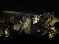
Tourtoirac Cave
.JPG)


Personalities
- Orélie Antoine de Tounens (1825–1878), lawyer, adventurer and self-proclaimed King of Araucania and Patagonia
- Achille Laviarde (1841–1902), adventurer, successor to Orélie de Tounens ("King of Araucania and Patagonia"), buried here
Web links