
Limeyrat
|
Limeyrat Limeirac |
||
|---|---|---|

|
|
|
| region | Nouvelle-Aquitaine | |
| Department | Dordogne | |
| Arrondissement | Sarlat-la-Canéda | |
| Canton | Haut-Périgord Noir | |
| Community association | Terrassonnais en Périgord Noir Thenon Hautefort | |
| Coordinates | 45 ° 10 ′ N , 0 ° 59 ′ E | |
| height | 143-266 m | |
| surface | 19.72 km 2 | |
| Residents | 445 (January 1, 2017) | |
| Population density | 23 inhabitants / km 2 | |
| Post Code | 24210 | |
| INSEE code | 24241 | |
| Website | http://www.limeyrat.net/ | |

Limeyrat ( Occitan Limeirac ) is a French commune with 445 inhabitants (as of January 1, 2017) in the Dordogne department in Nouvelle-Aquitaine (before 2016 Aquitaine ). It belongs to the arrondissement of Sarlat-la-Canéda (until 2017 Périgueux ) and the canton of Haut-Périgord Noir (until 2015 Thenon ).
geography
Limeyrat is located about 25 kilometers east-southeast of Périgueux. Limeyrat is surrounded by the neighboring communities of Montagnac-d'Auberoche in the north and north-west, Brouchaud in the north and north-east, Ajat in the east, Fossemagne in the south and Bassillac et Auberoche in the west and north-west.
The A89 autoroute runs through the municipality .
Population development
| year | 1962 | 1968 | 1975 | 1982 | 1990 | 1999 | 2006 | 2013 |
|---|---|---|---|---|---|---|---|---|
| Residents | 371 | 343 | 394 | 408 | 427 | 436 | 441 | 455 |
| Source: Cassini and INSEE | ||||||||
Attractions
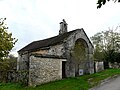
- Saint-Hilaire church from the 12th century, alterations from the 16th century, monument historique since 1903/2006
- Dolmen of Peyrelevade, Monument historique since 1980
- La Pinolie Chapel from the 17th century
- L'Étang castle from the 19th century
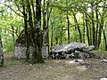
Peyrelevade dolmen

Saint-Hilaire church
Chapel of La Pinolie

L'Étang Castle


