
Florimont-Gaumier
|
Florimont-Gaumier Florimont e Gaumièr |
||
|---|---|---|
|
||
| region | Nouvelle-Aquitaine | |
| Department | Dordogne | |
| Arrondissement | Sarlat-la-Canéda | |
| Canton | Vallée Dordogne | |
| Community association | Domme Villefranche-du-Périgord | |
| Coordinates | 44 ° 42 ′ N , 1 ° 14 ′ E | |
| height | 116-288 m | |
| surface | 9.05 km 2 | |
| Residents | 142 (January 1, 2017) | |
| Population density | 16 inhabitants / km 2 | |
| Post Code | 24250 | |
| INSEE code | 24184 | |
 Town hall (Mairie) of Florimont-Gaumier |
||

Florimont-Gaumier ( Occitan : Florimont e Gaumièr ) is a French commune with 142 inhabitants (as of January 1, 2017) in the Dordogne department in Nouvelle-Aquitaine (before 2016 Aquitaine ). It belongs to the arrondissement of Sarlat-la-Canéda and the canton of Vallée Dordogne ( Domme until 2015 ). The inhabitants are called Florimontois .
geography
Florimont-Gaumier is about 57 kilometers east-southeast of Bergerac . Neighboring municipalities are Bouzic in the north and west, Saint-Martial-de-Nabirat in the north and northeast, Saint-Aubin-de-Nabirat in the northeast, Salviac in the south and east and Campagnac-lès-Quercy in the southwest.
Population development
| year | 1962 | 1968 | 1975 | 1982 | 1990 | 1999 | 2006 | 2013 |
|---|---|---|---|---|---|---|---|---|
| Residents | 262 | 252 | 230 | 181 | 164 | 132 | 140 | 142 |
| Source: Cassini and INSEE | ||||||||
Attractions
- Church of Saint Blaise in Florimont from the 12th century, monument historique since 1977
- Saint-Pierre-ès-Liens church in Gaumier from the 12th century, monument historique since 1974
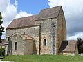
Saint Blaise Church

Saint-Pierre-ès-Liens church


Web links
Commons : Florimont-Gaumier - collection of images, videos and audio files