
Saint-Crépin-et-Carlucet
| Saint-Crépin-et-Carlucet | ||
|---|---|---|
|
||
| region | Nouvelle-Aquitaine | |
| Department | Dordogne | |
| Arrondissement | Sarlat-la-Canéda | |
| Canton | Terrasson-Lavilledieu | |
| Community association | Pays de Fénelon | |
| Coordinates | 44 ° 58 ′ N , 1 ° 17 ′ E | |
| height | 141-303 m | |
| surface | 18.51 km 2 | |
| Residents | 520 (January 1, 2017) | |
| Population density | 28 inhabitants / km 2 | |
| Post Code | 24590 | |
| INSEE code | 24392 | |
| Website | http://www.stcrepincarlucet.fr/ | |
 Town hall (Mairie) of Saint-Crépin-et-Carlucet |
||

Saint-Crépin-et-Carlucet is a French commune with 520 inhabitants (as of January 1, 2017) in the Dordogne department in Nouvelle-Aquitaine . It belongs to the arrondissement of Sarlat-la-Canéda and the canton of Terrasson-Lavilledieu .
geography
Saint-Crépin-et-Carlucet is located about 50 kilometers east-southeast of Périgueux . Neighboring municipalities are Saint-Geniès in the north, Salignac-Eyvigues in the east and northeast, Sainte-Nathalène in the south, Proissans in the south and southwest and Marcillac-Saint-Quentin in the west.
Population development
| year | 1962 | 1968 | 1975 | 1982 | 1990 | 1999 | 2006 | 2013 |
|---|---|---|---|---|---|---|---|---|
| Residents | 370 | 331 | 321 | 310 | 372 | 407 | 463 | 544 |
| Source: Cassini and INSEE | ||||||||
Attractions
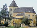
- Saint-Crépin church from the 12th century, monument historique since 1975
- Church of Sainte-Marie-et-Sainte-Anne in Carlucet, monument historique since 1977
- Castle Cipières (also: Castle Lacypierre) from the 15th / 16th centuries Century, since 1946 Monument historique

Saint-Crépin church
Sainte-Marie-et-Sainte-Anne church

Cipières Castle


Web links
Commons : Saint-Crépin-et-Carlucet - Collection of images, videos and audio files