
Tourtrès
| Tourtrès | ||
|---|---|---|
|
||
| region | Nouvelle-Aquitaine | |
| Department | Lot-et-Garonne | |
| Arrondissement | Villeneuve-sur-Lot | |
| Canton | Le Livradais | |
| Community association | Lot and Tolzac | |
| Coordinates | 44 ° 29 ′ N , 0 ° 31 ′ E | |
| height | 59-171 m | |
| surface | 11.71 km 2 | |
| Residents | 134 (January 1, 2017) | |
| Population density | 11 inhabitants / km 2 | |
| Post Code | 47380 | |
| INSEE code | 47313 | |
 Town Hall (Mairie) of Tourtrès |
||

Tourtrès ( Occitan identical) is a French city with a population of 134 (as at 1st January 2017) in the department of Lot-et-Garonne in the region Nouvelle-Aquitaine . The municipality is located in the arrondissement of Villeneuve-sur-Lot and is part of the canton of Le Livradais (until 2015: canton of Monclar ). The inhabitants are called Tourtrésiens .
geography
Tourtrès is about 32 kilometers north-northwest of Agen . Tourtrès is surrounded by the neighboring communities of Laperche in the north, Tombebœuf in the east, Coulx in the southeast, Verteuil-d'Agenais in the south, Labretonie in the southwest and Saint-Barthélemy-d'Agenais in the west.
Population development
| 1962 | 1968 | 1975 | 1982 | 1990 | 1999 | 2006 | 2013 |
|---|---|---|---|---|---|---|---|
| 205 | 168 | 152 | 139 | 132 | 121 | 123 | 144 |
| Source: Cassini and INSEE | |||||||
Attractions
- Saint-Pierre church, monument historique since 1957
- Windmill
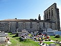
Saint-Pierre church
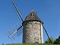
Windmill


Web links
Commons : Tourtrès - collection of images, videos and audio files