
Sauveterre-la-Lémance
|
Sauveterre-la-Lémance Salvatèrra de Lemança |
||
|---|---|---|
|
||
| region | Nouvelle-Aquitaine | |
| Department | Lot-et-Garonne | |
| Arrondissement | Villeneuve-sur-Lot | |
| Canton | Le Fumélois | |
| Community association | Fumel Vallée du Lot | |
| Coordinates | 44 ° 35 ' N , 1 ° 1' E | |
| height | 115-285 m | |
| surface | 23.46 km 2 | |
| Residents | 537 (January 1, 2017) | |
| Population density | 23 inhabitants / km 2 | |
| Post Code | 47500 | |
| INSEE code | 47292 | |
 Town Hall (Mairie) and Museum of Sauveterre-la-Lémance |
||

Sauveterre-la-Lémance ( Occitan : Salvatèrra de Lemança ) is a municipality with 537 inhabitants (as of January 1 2017) in France in the department of Lot-et-Garonne in the region Nouvelle-Aquitaine (2016: Aquitaine ). Sauveterre-la-Lémance is part of the Arrondissement of Villeneuve-sur-Lot and the Canton of Le Fumélois (until 2015: Canton of Fumel ). The inhabitants are called Sauveterrois .
geography
Sauveterre-la-Lémance is about 33 kilometers northeast of Villeneuve-sur-Lot . Sauveterre-la-Lémance is surrounded by the neighboring communities of Lavaur in the north and north-west, Loubejac in the north and east, Montcabrier in the south-east, Saint-Martin-le-Redon in the south, Saint-Front-sur-Lémance in the south-west and Blanquefort-sur- Briolance to the west.
Population development
| 1962 | 1968 | 1975 | 1982 | 1990 | 1999 | 2006 | 2013 |
|---|---|---|---|---|---|---|---|
| 977 | 873 | 824 | 743 | 685 | 623 | 603 | 552 |
| Source: Cassini and INSEE | |||||||
Attractions
- Saint-Barthélemy Church, 12th century, MH (1950)
- (2003), later joined Les Rois ducs, 13th century, MH of Jean Mermoz bought
- Neolithic Museum and Archaeological Site Martinet, MH (1932)
- Wayside cross, 15th century, MH (1910)

Église Saint-Barthélemy

Château Les Rois ducs
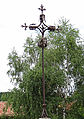
Wayside cross


