
Queyssac
| Queyssac | ||
|---|---|---|
|
||
| region | Nouvelle-Aquitaine | |
| Department | Dordogne | |
| Arrondissement | Bergerac | |
| Canton | Bergerac-2 | |
| Community association | Bergeracoise | |
| Coordinates | 44 ° 54 ' N , 0 ° 33' E | |
| height | 50-173 m | |
| surface | 12.35 km 2 | |
| Residents | 466 (January 1, 2017) | |
| Population density | 38 inhabitants / km 2 | |
| Post Code | 24140 | |
| INSEE code | 24345 | |
 The Seyze in the northeast of the municipality |
||

Queyssac ( Occitan : Caissac ) is a municipality with 466 inhabitants (as of January 1 2017) in the Dordogne department in southwestern France in the region Nouvelle-Aquitaine (2015 Aquitaine ). It belongs to the Arrondissement of Bergerac and to the municipality association Agglomération Bergeracoise, founded in 2016 . The inhabitants call themselves Queyssacois .
geography
Queyssac is located on the southern edge of the Périgord Blanc on the Seyze , a tributary of the Caudeau , about ten kilometers northeast of Bergerac and about 100 kilometers east of Bordeaux . In the very wooded municipal area, several hamlets are spread out on cleared islands, including Le Mortier, Floyrac, Les Archets, Le Reclaussou, Parouty, Le Grand Bos, La Mouthe and Pinceguerre (in part). The highest point in the municipality is located near Pinceguerre at 173 m above sea level. Queyssac is surrounded by the neighboring communities of Saint-Julien-de-Crempse in the north, Campsegret in the northeast, Lamonzie-Montastruc in the east, Lembras in the south and Maurens in the west.
history
An early settlement of today's municipal area can be proven by prehistoric finds from the Paleolithic and the Neolithic . The origin of the place name Queyssac derives from a domain of a Gallo - Roman owner named Cassius or Cursus . Several cave dwellings ( cluzeaux ) have survived from the Middle Ages . The Saint-Pierre-ès-Liens church was built in the 11th and 12th centuries, but the first references to the place first appear in the 13th century as Corssac and then at the end of the 14th century as Quayssacum . The village of Queyssec was mentioned on the Carte de Cassini , which was created between 1756 and 1789 .
Population development
| 1793 | 1962 | 1968 | 1975 | 1982 | 1990 | 1999 | 2006 | 2016 | |
|---|---|---|---|---|---|---|---|---|---|
| 603 | 276 | 256 | 289 | 363 | 439 | 462 | 467 | 470 | |
| Sources: Cassini and INSEE | |||||||||
Attractions
- Saint-Pierre-ès-Liens church
- former pigeon tower from the 16th century, today a grain silo
- Fallen memorial
- several hall crosses and fountains

former pigeon tower, now a granary
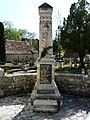
Fallen memorial

one of the fountains in Queyssac
.JPG)


- Saint-Pierre-ès-Liens church in Queyssac


.JPG)
.JPG)
.JPG)

Economy and Infrastructure
In the Queyssac municipality there are eight farms (grain and feed cultivation, dairy farming, cattle, goat and sheep breeding) and one winery. The vines in the municipality are part of the Sod-Ouest wine-growing region .
In the southeast of the commune, Queyssac is affected by Route nationale 21 , which leads from Bergerac to Périgueux . Ten kilometers away from the railway station Bergerac is situated on the railway line from Libourne to Le Buisson-de-Cadouin .
supporting documents
- ↑ Occitan place names in Périgord (French)
- ↑ Jean-Marie Cassagne and Mariola Korsak: Origine des noms de villes et villages de Dordogne, éditions Bordessoules, 2009
- ↑ Chantal Tanet and Tristan Hordé: Dictionnaire des noms de lieux du Périgord, éditions Fanlac, 2000, ( ISBN 2-86577-215-2 ), p. 279
- ↑ Queyssac on the Cassini card
- ↑ Queyssac on cassini.ehess.fr
- ↑ Queyssac on insee.fr
- ↑ Description of the church on queyssac.com (French)
- ↑ Farms on annuaire-mairie.fr (French)