Gageac-et-Rouillac
|
Gageac-et-Rouillac Gajac e Rolhàs |
||
|---|---|---|
|
|
||
| region | Nouvelle-Aquitaine | |
| Department | Dordogne | |
| Arrondissement | Bergerac | |
| Canton | Sud-Bergeracois | |
| Community association | Bergeracoise | |
| Coordinates | 44 ° 48 ' N , 0 ° 21' E | |
| height | 29-146 m | |
| surface | 13.99 km 2 | |
| Residents | 465 (January 1, 2017) | |
| Population density | 33 inhabitants / km 2 | |
| Post Code | 24240 | |
| INSEE code | 24193 | |
| Website | http://www.gageac-et-rouillac.fr/ | |
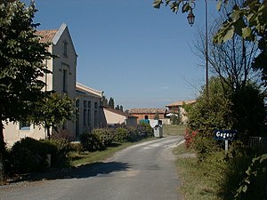
 View of the town of Gageac-et-Rouillac |
||
Gageac-et-Rouillac ( Occitan : Gajac e Rolhas ) is a French commune in the department of Dordogne in the region Nouvelle-Aquitaine . The municipality with 465 inhabitants (as of January 1, 2017) is located in the canton of Sud-Bergeracois (until 2015: canton Sigoulès ) and in the arrondissement of Bergerac .
geography
Gageac-et-Rouillac is located about twelve kilometers west-southwest of Bergerac in the Saussignac wine-growing region . Gageac-et-Rouillac is surrounded by the neighboring communities of Gardonne in the north and north-west, Lamonzie-Saint-Martin in the north and north-east, Pomport in the east, Cunèges in the south and south-east, Monestier in the south and south-west and Saussignac in the west.
Population development
| 1962 | 1968 | 1975 | 1982 | 1990 | 1999 | 2006 | 2017 | |
|---|---|---|---|---|---|---|---|---|
| 459 | 451 | 356 | 395 | 440 | 435 | 451 | 465 | |
| Sources: Cassini and INSEE | ||||||||
Attractions
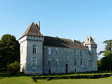
- Gageac Castle, originally from the 12th century, remodeling in the 16th century, monument historique since 1948
- former Carthusian monastery in Rouillac
Web links
Commons : Gageac-et-Rouillac - Collection of images, videos and audio files

