Sigoulès
| Sigoulès | ||
|---|---|---|

|
|
|
| local community | Sigoulès-et-Flaugeac | |
| region | Nouvelle-Aquitaine | |
| Department | Dordogne | |
| Arrondissement | Bergerac | |
| Coordinates | 44 ° 45 ′ N , 0 ° 25 ′ E | |
| Post Code | 24240 | |
| Former INSEE code | 24534 | |
| Incorporation | 1st January 2019 | |
| status | Commune déléguée | |
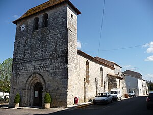
 Sigoulès - Église Saint-Jacques-le-Majeur |
||
Sigoulès ( Occitan Lo Sigolés ) is a village and a former community with 900 inhabitants (at January 1, 2017) in the Dordogne department in southwestern France in the region Nouvelle-Aquitaine (before 2016 Aquitaine ). Sigoulès belonged to the Arrondissement Bergerac and the Canton Sud-Bergeracois (until 2015: Canton Sigoulès ). The community consisted of the main town and several hamlets (hameaux) and individual farms (fermes) .
The decree of November 15, 2018 established the incorporation of Sigoulès as Commune déléguée together with the former municipality of Flaugeac into the Commune nouvelle Sigoulès-et-Flaugeac with effect from January 1, 2019 . The administrative headquarters are in Sigoulès.
The name in the Occitan language is Lo Sigoles and means "rye earth ".
The inhabitants are called Sigoulésiens and Sigoulésiennes .
Location and climate
The place is located in the Bergeracois in the southwest of the Périgord , about 15 km southwest of Bergerac in its catchment area ( Aire urbaine ) at an altitude of about 90 m . The climate is temperate; Rain (approx. 850 mm / year) falls over the year.
Sigoulès is surrounded by five neighboring municipalities and one delegated municipality:
| Cunèges | Pomport | |
| Thénac |

|
Flaugeac (Commune déléguée) |
| Saint-Julien-Innocence-Eulalie | Mescoules |
history
In the Hundred Years War (1337-1453) the region was fought over between the English and the French; The defensive character of the churches is to be understood against this background. In the second half of the 16th century, the Bergeracois joined Protestantism ; the place and its surroundings were involved in the decades of Huguenot Wars (1562–1598) in the Périgord.
Population development
The continuous decline in population since the second half of the 19th century is mainly due to the phylloxera crisis in viticulture as well as the mechanization of agriculture and the closure of small farms. The renewed increase in population at the beginning of the 21st century is due to the relative proximity to the city of Bergerac.
| year | 1962 | 1968 | 1975 | 1982 | 1990 | 1999 | 2006 | 2011 | 2017 |
|---|---|---|---|---|---|---|---|---|---|
| Residents | 571 | 616 | 600 | 574 | 603 | 694 | 789 | 872 | 900 |
Attractions
- The single-aisled Église Saint-Jacques-le-Majeur was built in the late 12th or early 13th century and is dedicated to the apostle Jakobus the Elder. consecrated. Its rather unadorned west facade is dominated by a massive bell gable (clocher mur) ; the Gothic portal and the two buttresses placed across the corner date from the 15th century - as do the large pointed arch windows inside. The wooden ceiling above the nave was renewed in 1960.
- Surroundings
- The Église Saint-Michel in the hamlet of Lestignac with its also rectangular bell gable was built in the 13th century; at the time of its construction it belonged to the sphere of influence of the archpriest of Flaugeac . In the 15th century a new portal in the late Gothic flamboyant style was built; in the 19th century the apse was reduced in size to create a sacristy . The church building is surrounded by the local cemetery; the ensemble has been recognized as a monument historique since 1988 .
Web links
Individual evidence
- ↑ RECUEIL DES ACTES ADMINISTRATIFS N ° 24-2018-039 ( fr , PDF) Dordogne department. Pp. 65-69. November 15, 2018. Retrieved January 24, 2019.
- ↑ Le nom occitan des communes du Périgord ( fr ) Départementrat des Dordogne. Retrieved January 24, 2019.
- ↑ Dordogne ( fr ) habitants.fr. Retrieved January 24, 2019.
- ↑ Sigoulès - climate diagrams
- ↑ Aire urbaine de Bergerac (109) ( fr ) INSEE . Retrieved January 24, 2019.
- ^ Notice Communale Sigoulès ( fr ) EHESS . Retrieved January 24, 2019.
- ↑ Populations légales 2016 Commune de Sigoulès (24534) ( fr ) INSEE . Retrieved January 24, 2019.
- ↑ Sigoulès - Church
- ^ Sigoulès - Church in the Base Mérimée of the French Ministry of Culture (French)
- ↑ Sigoulès / Lestignac - Church

