Saint-Geyrac
| Saint-Geyrac | ||
|---|---|---|
|
|
||
| region | Nouvelle-Aquitaine | |
| Department | Dordogne | |
| Arrondissement | Périgueux | |
| Canton | Isle Manoire | |
| Community association | Le Grand Périgueux | |
| Coordinates | 45 ° 5 ' N , 0 ° 55' E | |
| height | 153-257 m | |
| surface | 17.1 km 2 | |
| Residents | 198 (January 1, 2017) | |
| Population density | 12 inhabitants / km 2 | |
| Post Code | 24330 | |
| INSEE code | 24421 | |
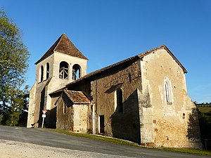
 Saint Cyr Church |
||
Saint-Geyrac is a French municipality with 198 inhabitants (at January 1, 2017) in the department of Dordogne in the region Nouvelle-Aquitaine ; it belongs to the Arrondissement Périgueux and the canton Isle-Manoire .
geography
The municipality is located around 20 kilometers southeast of Périgueux , neighboring municipalities are:
- Saint-Crépin-d'Auberoche in the north,
- Milhac-d'Auberoche in the northeast,
- Rouffignac-Saint-Cernin-de-Reilhac in the east and south-east,
- Saint-Félix-de-Reillac-et-Mortemart in the south,
- La Douze in the southwest and
- Saint-Pierre-de-Chignac in the north-west.
The place is located on the Saint-Geyrac river of the same name .
Transport links
The community is away from national traffic routes, the place is accessed from the Départementsstraße D6.
history
Population development
| year | 1968 | 1975 | 1982 | 1990 | 1999 | 2006 | 2010 |
| Residents | 253 | 244 | 235 | 212 | 199 | 220 | 241 |
Attractions
- Saint Cyr church from the 12th century - Monument historique
Web links
Commons : Saint-Geyrac - Collection of images, videos and audio files
Individual evidence
- ↑ Église Saint Cyr in the Base Mérimée of the French Ministry of Culture (French)
