
Agonac
| Agonac | ||
|---|---|---|
|
||
| region | Nouvelle-Aquitaine | |
| Department | Dordogne | |
| Arrondissement | Périgueux | |
| Canton | Trélissac | |
| Community association | Le Grand Périgueux | |
| Coordinates | 45 ° 18 ′ N , 0 ° 45 ′ E | |
| height | 110-224 m | |
| surface | 37.22 km 2 | |
| Residents | 1,761 (January 1, 2017) | |
| Population density | 47 inhabitants / km 2 | |
| Post Code | 24460 | |
| INSEE code | 24002 | |
| Website | http://www.agonac.com/ | |

Agonac is a commune with 1,761 inhabitants (as of January 1 2017) in the north of the department Dordogne in the region Nouvelle-Aquitaine (before 2016: Aquitaine ). The municipality belongs to the Arrondissement Périgueux and the canton Trélissac (until 2015: canton Brantôme ). The inhabitants are called Agonacois .
geography
Agonac is twelve kilometers north-northeast of Périgueux on the Beauronne . Agonac is surrounded by the neighboring communities of Saint-Front-d'Alemps in the north-east, Sorges in the east, Cornille in the south-east, Champcevinel in the south, Château-l'Évêque in the west and south-west and Brantôme en Périgord in the north-west.
Population development
| 1962 | 1968 | 1975 | 1982 | 1990 | 1999 | 2006 | 2012 | |
|---|---|---|---|---|---|---|---|---|
| 1,211 | 1,162 | 1,027 | 1,059 | 1,342 | 1,451 | 1,600 | 1,690 | |
| Source: Cassini and INSEE | ||||||||
Community partnerships
A partnership has existed with the Spanish municipality of Almunia de San Juan in the Aragon region since 1984.
Attractions
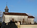
- Saint-Martin church from 11th / 12th centuries Century, restored at the end of the 19th century, Monument historique since 1900
- Notre-Dame chapel from the 19th century
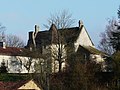
- Charterhouse of Le Pouliquet from the 19th century
- Agonac castle and chateau from the 10th century, rebuilt in the 19th century
- Agonac mansion, built at the end of the 18th century
- Gourjou castle with chapel
- Salseyron gate from the 14th century
- 17th century hospice with pigeon tower

Saint Martin Church
Notre-Dame chapel

Charterhouse Le Pouliquet
Agonac Castle

Agonac mansion
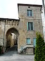
Gate Salseyron
.JPG)
.JPG)
.JPG)
.JPG)
.JPG)

Personalities
- Michel Chadeuil (* 1947), writer