
Annesse-et-Beaulieu
| Annesse-et-Beaulieu | ||
|---|---|---|
|
||
| region | Nouvelle-Aquitaine | |
| Department | Dordogne | |
| Arrondissement | Périgueux | |
| Canton | Saint-Astier | |
| Community association | Le Grand Périgueux | |
| Coordinates | 45 ° 11 ′ N , 0 ° 36 ′ E | |
| height | 65-169 m | |
| surface | 12.12 km 2 | |
| Residents | 1,436 (January 1, 2017) | |
| Population density | 118 inhabitants / km 2 | |
| Post Code | 24430 | |
| INSEE code | 24010 | |
| Website | http://www.annesse-et-beaulieu.fr/ | |
 Town hall (Mairie) of Annesse-et-Beaulieu |
||

Annesse-et-Beaulieu ( Occitan : Anessa e Beuluòc ) is a French municipality with 1436 inhabitants (as of January 1 2017) in the department of Dordogne in the region Nouvelle-Aquitaine ; it belongs to the Arrondissement of Périgueux and the canton of Saint-Astier . The inhabitants are called Annessois or Gravellois .
geography
Annesse-et-Beaulieu is located about ten kilometers west-southwest of Périgueux in the Périgord countryside . The river Isle limits the parish to the south and east. The neighboring municipalities of Annesse-et-Beaulieu are La Chapelle-Gonaguet in the north, Chancelade in the northeast, Marsac-sur-l'Isle in the east, Razac-sur-l'Isle in the southeast, Montrem in the south, Saint-Astier in the southwest, Léguillac-de-l'Auche in the west and Mensignac in the north-west.
Population development
| year | 1962 | 1968 | 1975 | 1982 | 1990 | 1999 | 2006 | 2013 |
| Residents | 531 | 553 | 631 | 826 | 1,099 | 1,246 | 1,418 | 1,493 |
| Source: Cassini and INSEE | ||||||||
Attractions
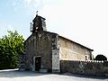
- Saint Blaise church in Annesse from the 12th century
- Saint-Mandé church in Beaulieu from the 12th century
- Priory and old rectory
- Lalande Castle from the 18th century
- 19th century castle La Roche
- Siorac Castle from the 16th century

Saint Blaise Church
Saint-Mandé church
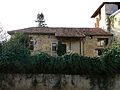
priory

Lalande Castle

La Roche Castle

Siorac Castle
.JPG)


.JPG)
.JPG)
.JPG)