
Le Pizou
|
Le Pizou Lo Pison |
||
|---|---|---|

|
|
|
| region | Nouvelle-Aquitaine | |
| Department | Dordogne | |
| Arrondissement | Périgueux | |
| Canton | Montpon-Ménestérol | |
| Community association | Isle Double Landais | |
| Coordinates | 45 ° 2 ′ N , 0 ° 4 ′ E | |
| height | 19-102 m | |
| surface | 17.02 km 2 | |
| Residents | 1,317 (January 1, 2017) | |
| Population density | 77 inhabitants / km 2 | |
| Post Code | 24700 | |
| INSEE code | 24329 | |
| Website | http://www.lepizou.fr/ | |
 Town hall (Mairie) of Le Pizou |
||

Le Pizou ( Occitan : Lo Pison ) is a French municipality with 1317 inhabitants (as of January 1 2017) in the department of Dordogne in the region Nouvelle-Aquitaine ; it belongs to the Arrondissement of Périgueux and the canton of Montpon-Ménestérol .
geography
Le Pizou is located about 38 kilometers northeast of Bergerac in the Périgord on the river Isle , which borders the municipality in the south. The neighboring municipalities of Le Pizou are Eygurande-et-Gardedeuil in the north and northeast, Montpon-Ménestérol in the east, Ménesplet in the southeast, Moulin-Neuf in the south and Saint-Antoine-sur-l'Isle in the west.
Population development
| year | 1962 | 1968 | 1975 | 1982 | 1990 | 1999 | 2006 | 2017 |
| Residents | 1035 | 1037 | 1251 | 1255 | 1172 | 1094 | 1159 | 1317 |
| Sources: Cassini and INSEE | ||||||||
Attractions
- Notre-Dame-de-l'Assomption church from the 17th century
- Le Désert Castle, 18th century manor house

Notre-Dame-de-l'Assomption church
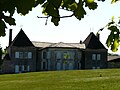
Le Désert Castle
.JPG)
.JPG)
Web links
Commons : Le Pizou - collection of images, videos and audio files