
Nantheuil
| Nantheuil | ||
|---|---|---|

|
|
|
| region | Nouvelle-Aquitaine | |
| Department | Dordogne | |
| Arrondissement | Nontron | |
| Canton | Thiviers | |
| Community association | Périgord-Limousin | |
| Coordinates | 45 ° 25 ' N , 0 ° 57' E | |
| height | 138-312 m | |
| surface | 16.82 km 2 | |
| Residents | 966 (January 1, 2017) | |
| Population density | 57 inhabitants / km 2 | |
| Post Code | 24800 | |
| INSEE code | 24304 | |
| Website | http://www.nantheuil.fr/ | |
 Town hall (Mairie) of Nantheuil |
||

Nantheuil ( Occitan : Nantuelh ) is a municipality with 966 inhabitants (as of January 1, 2017) in the French department Dordogne in the Nouvelle-Aquitaine region . The municipality belongs to the Arrondissement of Nontron and the Canton of Thiviers . The inhabitants are called Nantheuillais .
geography
Nantheuil is located about 30 kilometers north-east of Périgueux on the river Isle , which borders the municipality in the east. Nantheuil is surrounded by the neighboring communities of Saint-Paul-la-Roche in the north and northeast, Sarrazac in the east, Nanthiat in the east and southeast, Corgnac-sur-l'Isle in the south and Thiviers in the west.
Population development
| 1962 | 1968 | 1975 | 1982 | 1990 | 1999 | 2006 | 2013 |
|---|---|---|---|---|---|---|---|
| 872 | 826 | 860 | 921 | 932 | 901 | 1.011 | 960 |
| Source: Cassini and INSEE | |||||||
Attractions
- Saint-Étienne church from the 16th century, monument historique
- Manor house Nantheuil from the 15th century, later renovations

Saint-Etienne church
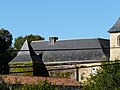
Nantheuil mansion
.JPG)

Web links
Commons : Nantheuil - collection of images, videos and audio files