
Sceau-Saint-Angel
|
Sceau-Saint-Angel verse Ceus Sent Angeu |
||
|---|---|---|
|
||
| region | Nouvelle-Aquitaine | |
| Department | Dordogne | |
| Arrondissement | Nontron | |
| Canton | Périgord Vert Nontronnais | |
| Community association | Périgord Nontronnais | |
| Coordinates | 45 ° 29 ′ N , 0 ° 42 ′ E | |
| height | 157-262 m | |
| surface | 17.49 km 2 | |
| Residents | 124 (January 1, 2017) | |
| Population density | 7 inhabitants / km 2 | |
| Post Code | 24300 | |
| INSEE code | 24528 | |
 Church of Saint-Angel |
||

Sceau-Saint-Angel , Occitan verse Ceus Sent Angeu , is a commune with 124 inhabitants (at January 1, 2017) of the North department Dordogne in the region Nouvelle-Aquitaine . It belongs to the Arrondissement of Nontron and the canton of Périgord Vert Nontronnais (until 2014: Nontron ). The responsible community association is the Communauté de communes du Périgord Nontronnais . The inhabitants are called Scellois or Scelloises .
etymology
Saint-Angel or Sent Angeu is derived from the Holy Angelus . The archangel Michael may also be referred to. The name Sceau is a French contraction of the Occitan verse (after, towards) Ceus , whereby Ceus may have emerged from the Latin cellis (monastery cells).
geography
Sceau-Saint-Angel is just under six kilometers (as the crow flies) south-southeast of Nontron and four kilometers west-southwest of Saint-Pardoux-la-Rivière . Périgueux in the south is 33 kilometers away.
Sceau-Saint-Angel is surrounded by the following seven neighboring municipalities:
| Saint-Martial-de-Valette | Nontron | Saint-Pardoux-la-Rivière |
| Saint-Front-sur-Nizonne |
.svg)
|
Saint-Front-la-Rivière |
| La Chapelle-Montmoreau | Quinsac |
The municipality of Sceau-Saint-Angel includes the following hamlets, farms, a castle and landmarks:
Argentine , Battelière , Beauvoir , Bellegarde , Bois Coupé , Bois de l'Age , Bois des Biches , Bois des Cocus , Brissonneau , Broillac , Château de l'Age , Courrière , Garreloup , Grand Clos , Jayac , L'Abîme , La Bure , La Croix de Nadaillac , La Croix des Chemins , La Grésille , La Pouyade , La Sacaude , Lage , Laglant , Le Caillou , Le Châtaignier , Le Grand Mazerat , Le Jardin Anglais , Le Petit Clos , Le Petit Mazerat , Le Pouyaud , Les Garennes , Les Taillis de la Grézille , Morelière , Puymezier , Saint-Angel , Sarelière , Sceau , Terme de la Roue , Tourbanier and Vignaud .
The topographically lowest point of the municipality is at 157 meters above sea level at Broillac in the northeast, the highest point at 262 meters at Brissonneau in the northwest. The maximum difference in altitude is 105 meters. Sceau is at 238 meters, Saint-Angel at 208 meters above sea level.
The vast majority of the municipality of Sceau-Saint-Angel is taken up by extensive forests.
Transport links

The D 675 runs through the western part of the municipality of Sceau-Saint-Angel in a southerly direction from Nontron to Brantôme . The D 3 also crosses from Nontron to Villars in a south-east direction; a municipal road branches off from it, which leads through the center of Sceau and then continues to Saint-Front-la-Rivière. The town center is also crossed by a municipal road coming up from Saint-Pardoux, which then connects to the D 675. From the latter communal road there is a junction at Garreloup to Saint-Angel and on to Quinsac.
The now closed Quéroy-Pranzac-Thiviers railway once ran through the northern part of the municipality .
Hydrography
The Nizonne, which flows off to the west, has its source near the hamlet of Morelière . The source of the Boulou , which drains to the southwest , is in the immediate vicinity of Saint-Angel . A small stream that rises north of Sarelière drains the northeast of the municipality towards Dronne (to the east-southeast). The watershed between Nizonne and Boulou on the one hand and Dronne on the other runs roughly through the middle of the municipality. The north-western border forms the watershed between Bandiat and Dronne.
geology
The community of Sceau-Saint-Angel is located entirely on flat sediments of the northeastern Aquitaine Basin , which are largely concealed by the continental Tertiary and can only be seen along rivers and their slopes.
The North East of the municipality is from Lia ( Pliensbachian below Puymezier - gray-blue Dolomite the formation l5-9 ) of limestones (bioclastic limes, crypto-crystalline limestones and Oolithkalke ) of Doggers ( Bajocium the formation J1B-2a and Bathonian the formation J2B throughout the northeast section ) and from the lowest Malm ( Oxfordium at Le Petit Mazerat , formations j2-6 (a) and j2-6 (b) ). The Dogger can also be recrystallized in places, such as around Jayat .
Immediately below Sceau, Cenomanium (formation c1-2 ) transgresses over the Jurassic succession. The upper runs of the Nizonne and Boulous be of flat-lying, Upper Cretaceous layers of Ligériens lined ( Unterturon - Formation c3a ). In Vignaud even stands Angoumian (- Formation Oberturon c3b ) to.
Old Pleistocene alluvium (of fluvial origin) and colluvial alterites (continental rearrangements on slopes - gravel and sand ) then cover or cover most of the municipal area and mask the underlying Mesozoic sediments. Fluviatile Old Pleistocene (Formation Fs ) is found along the north-western elevations around Brissonneau and above Sceau . The colluvial alterites are either reprocessing products of the Mesozoic Era (Formation AC ) or the Old Pleistocene (Formation ACF ). They occupy the extensive ridges of the watersheds and are made up of forest.
Limestone debris from the Würm glacial period was introduced into the ramified valley of the Boulous near Saint-Angel (Formation GP ), but the river itself flows in a Holocene alluvium (Formation K ). Holocene alluvium is also found in the upper reaches of the Nizonne. Ice-age limestone debris also fills the stream on the northeast border.
Several south-east trending faults are assumed for the northeast section , which should run roughly parallel to the marginal fault of Le Puy (municipality of Nontron) further to the east, where the crystalline Variscan basement (here paragneiss - ζ 1-2 ) compared to the Aquitaine sediments Basin was lifted out. The presence of recrystallized Doggers also suggests interference.
ecology

Natural park
The municipality of Sceau-Saint-Angel is an integral part of the Périgord-Limousin Regional Natural Park .
Protected areas
The upper reaches of Boulou and Nizonne with their wet lowlands form ecotopes of regional importance, which have been designated as ZNIEFF ( French zone naturelle d'interêt écologique, faunistique et floristique ). There are plans to place the entire further course of the Boulous - already classified as ZNIEFF of type 2 - under Natura 2000 protection. The Nizonne also forms a Type 2 ZNIEFF.
The upper reaches of the Boulous - a type 1 ZNIEFF - is characterized by a high level of biodiversity (6 amphibians, 6 reptiles, 79 birds, 233 insects and 10 plants). Characteristic are the taxa jackdaw crab ( Austropotamobius pallipes ), slow worm ( Anguis fragilis ), common frog ( Rana temporaria ), western mud diver ( Pelodytes punctatus ), European tree frog ( Hyla arborea ), yellow-bellied toad ( Bombina variegata ) and marble newt ( Triturus marmoratus ) insect helmet Azurjungfer ( Coenagrion mercuriale ) Cupido Alcetas ( Cupid Alcetas ) -spotted blue ( Phengaris Arion ) golden-ringed dragonfly ( Cordulegaster boltonii ) Large Copper ( Lycaena dispar ), Marsh Fritillary ( Euphydryas aurinia ), Common antlion ( Myrmeleon formicarius ), Common Clubtail ( Gomphus vulgatissimus ), stain Bindiger neck Bock ( Pachytodes erraticus ) which Schwebfliege Milesia crabroniformis , the Weber Bock Musaria rubropunctata , the forceps dragonfly Onychogomphus uncatus , mirror spot Dickkopffalter ( Heteropterus morpheus ) apatura ilia ( Apatura ilia ) and evening primrose hawkmoth ( Proserpinus proserpina ).
history
The oldest cultural evidence in Sceau-Saint-Angel is the Romanesque church of Saint-Angel, which, however, was structurally changed in the 18th century . The Gothic chapel of La Pouyade dates from the 14th century .
In 1868 the community, which until then was only called Saint-Angel, was renamed Sceau-Saint-Angel (the district of Sceau is much more important than Saint-Angel ).
Population development
| Population development in Sceau-Saint-Angel | ||||
|---|---|---|---|---|
| year | Residents |

|
||
| 1962 | 191 | |||
| 1968 | 192 | |||
| 1975 | 149 | |||
| 1982 | 129 | |||
| 1990 | 122 | |||
| 1999 | 116 | |||
| 2006 | 121 | |||
| 2007 | 121 | |||
| 2008 | 122 | |||
| 2016 | 123 | |||
| 2017 | 124 | |||
Source: INSEE
The population of Sceau-Saint-Angels has suffered severe losses since 1968, but seems to have stabilized again from 1999.
With an area of 17.49 square kilometers, the population density is 7 inhabitants / km² - the lowest in the canton of Périgord Vert Nontronnais.
mayor
Mayor of Sceau-Saint-Angel has been the PCF pensioner Michel Combeau since 2001 .
Attractions
- Romanesque church of Saint-Michel in Saint-Angel
- 14th century Gothic chapel by La Pouyade
- Château de l'Age
- Beauvoir , a U-shaped farm from the 16th century
Photo gallery
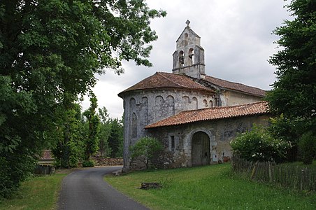 Saint-Michel church in Saint-Angel
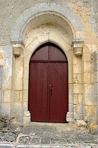 Entrance portal of the Saint-Michel church
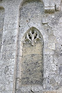 Decorative blind window on the Saint-Michel church
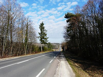 D 675 towards Nontron at Morelière
 The chapel of La Pouyade


Individual evidence
literature
- J.-P. Floc'h et al .: Feuille Nontron . In: Carte géologique de la France à 1/50000 . BRGM.